NOAA's GOES-13 satellite has been continuously providing imagery of Ernesto. A visible image of Tropical Storm Ernesto from GOES-13 on August 6 at 11:45 a.m. EDT showed an organized, rounded storm with strong convection (rising air that forms the thunderstorms that make up a tropical cyclone).
At 11 a.m. EDT (1500 UTC) Tropical Storm Ernesto's maximum sustained winds were near 65 mph (100 kmh). The National Hurricane Center (NHC) expects Ernesto to strengthen into a hurricane later in the day. The center was only 190 miles (205 km) east-northeast of Cabo Gracias A Dios on the Nicaragua/Honduras border, near latitude 15.8 north and longitude 80.5 west. Ernesto is moving toward the west-northwest near 9 mph (15 kmh) and that general motion is expected to continue for the next two days. Because Ernesto has continued moving west, the Cayman Islands discontinued their tropical storm watch for Grand Cayman. The NHC noted that "Ernesto's center will be passing north of the coast of Honduras tonight and Tuesday and approach the east coast of the Yucatan peninsula early Wednesday."

An animation of satellite observations shows the progression of Tropical Storm Ernesto from Aug. 4-6, 2012. The animation begins when Ernesto was south of Jamaica and ends when the storm is south of Cuba. This visualization was created by the NASA GOES Project at NASA Goddard Space Flight Center, Greenbelt, Md., using observations from NOAA's GOES-13 satellite.
(Photo Credit: NASA/NOAA GOES Project)
The NHC summarized the watches and warnings in effect today, August 6, 2012: The government of Mexico has issued a hurricane warning for the east coast of the Yucatan peninsula from Chetumal northward to Punta Allen and has issued a tropical storm warning from north of Punta Allen to Tulum. The government of Mexico has also issued a Tropical Storm Watch from north of Tulum to Chetumal. In Belize, there's a hurricane watch for the entire coast.
Ernesto is expected to strengthen to hurricane status by the end of the day on Monday, August 6.
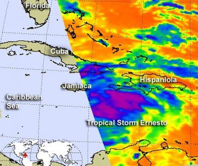
NASA's Aqua satellite passed over Tropical Storm Ernesto on Aug. 5 at 1753 UTC (1:53 p.m. EDT). The AIRS instrument captured an infrared image of the eastern half of the storm where cloud temperatures exceeded -63 Fahrenheit (-52 Celsius) indicating strong thunderstorms with heavy rainfall (purple).
(Photo Credit: NASA JPL, Ed Olsen)
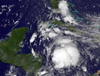
This visible image of Tropical Storm Ernesto was captured by NOAA's GOES-13 satellite on Aug. 6 at 11:45 a.m. EDT. Ernesto was located south of central Cuba at that time.
(Photo Credit: NASA GOES Project)
Source: NASA/Goddard Space Flight Center