The first tropical cyclone in the Northern Indian Ocean this season has been getting better organized as seen in NASA satellite imagery. Tropical Cyclone Mahasen is projected to track north through the Bay of Bengal and make landfall later this week.
The Moderate Resolution Imaging Spectroradiometer (MODIS) instrument aboard NASA's Aqua satellite captured a visible image of Tropical Cyclone Mahasen in the Northern Indian Ocean on May 15 at 07:55 UTC (3:55 a.m. EDT). The image was created by NASA's MODIS Rapid Response Team at NASA's Goddard Space Flight Center in Greenbelt, Maryland and showed Mahasen had consolidated over the last two days. Mahasen appeared rounded and its strongest thunderstorms appeared to be surrounding the center of circulation. The center also appears to be topped with a large dense overcast. The image showed Mahasen's center was northeast of Sri Lanka, although a band of strong thunderstorms south of the storm's center were affecting the island nation at the time of the image.
On Monday, May 13 at 0900 UTC (5 a.m. EDT) Mahasen had maximum sustained winds near 50 knots (57.5 mph/92.6 kph). Those winds are expected to increase of the next couple of days. Mahasen was centered near 12.1 north latitude and 86.3 east longitude in the Bay of Bengal, and about 660 nautical miles (759.5 miles/ 1,222 km) south of Kolkata, India. Mahasen is moving to the northwest at 4 knots (4.6 mph/7.4 kph), but is expected to move in a more northerly direction as a result of interaction with a mid-latitude trough (elongated area) of low pressure moving in from the west.
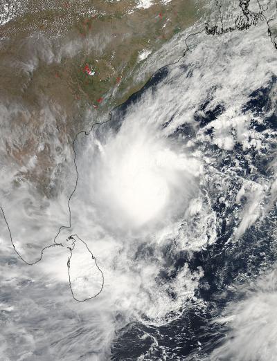
NASA's Aqua satellite captured this visible image of a well-rounded Tropical Cyclone Mahasen in the Northern Indian Ocean on May 15 at 07:55 UTC (3:55 a.m. EDT). Mahasen is northeast of Sri Lanka and moving northward.
(Photo Credit: : NASA Goddard MODIS Rapid Response Team)
The storm is expected to reach hurricane force by May 15 as it curves northwest. The current forecast track from the Joint Typhoon Warning Center takes the center of Mahasen just north of Chittagong early on May 17 and into northern Burma. Residents in Bangladesh and Burma should begin making preparations for storm surge, heavy rain and strong wind
Source: NASA/Goddard Space Flight Center