Infrared data from NASA's Aqua satellite have watched the strong thunderstorms in Typhoon Bopha fizzle and shrink in area over the weekend as wind shear increased. Bopha has now dissipated in the South China Sea, just west of Luzon, Philippines.
NASA's Aqua satellite has been providing data on Bopha since the day it formed on Nov. 26. In the storm's last days, Aqua's Atmospheric Infrared Sounder (AIRS) instrument captured infrared data of the storm and showed that cloud top temperatures warmed from Dec. 8 through Dec. 9 as cloud heights fell and thunderstorms lost their punch.
AIRS infrared data reveals where the coldest, highest cloud tops are located in a tropical cyclone. The coldest cloud tops indicate the strongest storms with the heaviest rain. On Dec. 8, AIRS data revealed a large area of strong thunderstorms surrounded the center of circulation as the storm skirted the west coast of Luzon, the northern Philippines. That same day, Bopha triggered more warnings for the Philippines.
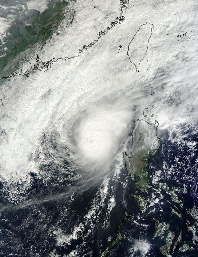
The MODIS instrument aboard NASA's Terra satellite captured this image of Bopha on Dec. 8 at 02:45 UTC (Dec. 7 at 9:45 p.m. EST/US) after it had regained typhoon status and was headed toward Luzon, Philippines.
(Photo Credit: NASA Goddard MODIS Rapid Response Team)
Just one day before, Typhoon Bopha's maximum sustained winds were up to 110 knots (126 mph/203.7 kph), but increased wind shear started taking a toll on the storm. As Bopha moved closer to Luzon (northern Philippines), warnings were posted on Dec. 8. Public storm warning signal #2 was in effect in the Luzon provinces of Ilocos Norte & Sur and La Union; and Public storm warning signal #1 was in effect in the Luzon provinces of Cagayan, Calayan group of islands, Babuyan group of islands, Batanes group of islands, Abra, Apayao, Kalinga, Mt. Province, Benguet, Pangasinan. At 2100 UTC (4 p.m. EST/U.S.), Bopha's maximum sustained winds were near 45 knots (51.7 mph/83.3 kph), so it was still a tropical storm. Overnight on Dec. 8 into Dec. 9, wind shear increased and Bopha weakened into a tropical depression.
By Dec. 9 at 0300 UTC (Dec. 8 at 10 p.m. EST/U.S.) the Joint Typhoon Warning Center issued its final advisory on Bopha. At that time it was a tropical depression located near 18.3 north latitude and 119.2 east longitude, about 240 miles north-northwest of Manila, Philippines. The depression was moving slowly at 3 knots (3.4 mph/5.5 kph) to the northeast and dissipating under adverse atmospheric conditions just west of Luzon.
On Dec. 9, AIRS data showed quite a different picture as the strongest thunderstorms no longer surrounded the center of circulation and were blown away from the center because of wind shear. The area of strong thunderstorms had also diminished greatly, indicating a weakening storm. Wind shear had taken its toll on this once deadly storm and had blown it apart.
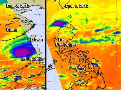
This side-by-side image shows Typhoon Bopha on Dec. 8 (left) and Dec. 9 (right). NASA AIRS infrared data revealed the strongest thunderstorms (purple) within Typhoon Bopha surrounded the center of circulation on Dec. 8. On Dec. 9 the strongest thunderstorms were located just northwest of Luzon, and had almost disappeared.
(Photo Credit: NASA JPL, Ed Olsen)
Source: NASA/Goddard Space Flight Center