NASA satellite data was an "eye opener" when it came to Tropical Cyclone 15S, now known as Guito in the Mozambique Channel today, Feb. 19, 2014. NASA's Aqua satellite passed over Guito and visible imagery revealed a ragged eye had developed as the tropical cyclone intensified.
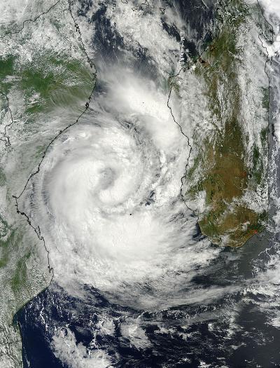
The Moderate Resolution Imaging Spectroradiometer or MODIS instrument aboard NASA's Aqua satellite captured a visible image of Tropical Cyclone Guito on Feb. 19 at 1140 UTC/6:40 a.m. EST as it continued moving south through the Mozambique Channel. The image revealed a ragged-looking eye with a band of strong thunderstorms wrapping from the northwestern to the southeastern quadrants of the storm.
On Feb. 19 at 1500 UTC/10 a.m. EST, Tropical Cyclone Guito's maximum sustained winds near 60 knots/69 mph/111 kph. Guito was centered near 21.5 south latitude and 39.6 east longitude, about 405 nautical miles/466.1 miles/750.1 km west of Antananarivo, Madagascar. Guito has been moving to the south at 10 knots/11.5 mph/18.2 kph.
The MODIS instrument aboard NASA's Aqua satellite captured this image of Tropical Cyclone Guito on Feb. 19 at 1140 UTC/6:40 a.m. EST as it continued moving south through the Mozambique Channel in the Southern Indian Ocean.
(Photo Credit: Image : NASA/NRL)
The Joint Typhoon Warning Center or JTWC noted that a mid-latitude trough (elongated area) of low pressure is approaching Guito from the southwest. That trough is expected to cause Guito to recurve southeastward as the storm transitions into an extra-tropical storm over the next couple of days.
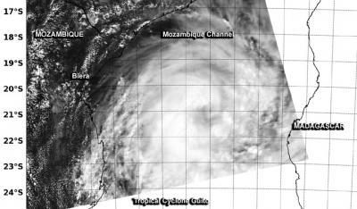
On Feb. 19 at 07:15 UTC/2:15 a.m. EST, the MODIS instrument aboard NASA's Terra satellite captured this visible image of Tropical Cyclone Guito in the Mozambique Channel, showing a ragged eye developing.
(Photo Credit: : NASA Goddard MODIS Rapid Response Team)
Source: NASA/Goddard Space Flight Center