The GOES animation of the severe weather outbreak is in a large-format HDTV movie that runs 30 seconds. "The animation runs through the period of April 14-15, 2012 and the GOES imagery reveals the strong flow of warm, moist air from the Gulf into the advancing cold front," said Dennis Chesters of NASA's GOES Project.
The destructive outbreak was Saturday night, April 14 to Sunday morning, April 15, and appears half way through the GOES video, when the long streak of clouds springs into view in the middle of the frame. Although there is not much detail in the infrared-only cloud tops, there is evidence of sudden violence.
Meteorologists had predicted the set up for severe weather days in advance. In fact, the NOAA Storm Prediction Center Days sent out the alert to more five states to be on guard for developing "extremely dangerous" or "catastrophic" weather conditions. The states included Nebraska, Kansas, Iowa, Oklahoma, Missouri, Texas, and Illinois.
As factors came together, the National Weather Service forecast this week's Great Plains Tornado outbreak 24 hours in advance, and gave prompt and urgent warnings that saved lives. Six fatalities were recorded, and there were 213 severe thunderstorm warnings and 124 tornado warnings.

This animation of GOES data runs through the period of April 14-15, 2012. The imagery reveals the strong flow of warm, moist air from the Gulf into an advancing cold front. There were more than 135 reports of tornadoes and 124 different warnings during this period.
(Photo Credit: (: NASA/NOAA GOES Project))
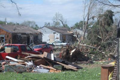
This image shows damage left behind from the tornadoes that struck Wichita, Kansas, on April 14, 2012. On April 15, media, Governor Brownback, Mayor Carl Brewer and other city and state officials toured damages.
(Photo Credit: (Image courtesy KWCH-TV/ Tim VanderZwaag, Wichita, Ks.))
Source: NASA/Goddard Space Flight Center