The deadly typhoon that caused almost 300 deaths in the southern Philippines is making a loop in the South China Sea, and infrared NASA satellite data indicated that Bopha re-intensified.
NASA's Aqua satellite passed over Bopha on Dec. 6 at 1811 UTC (1:11 p.m. EST, U.S.) and the Atmospheric Infrared Sounder (AIRS) instrument aboard captured an infrared look at the storm. The infrared data revealed where the coldest, highest cloud tops were. The coldest cloud tops indicate the strongest storms with the heaviest rain, and AIRS data revealed they surrounded the center of circulation and were in bands of thunderstorms north and northeast of the center, just skirting the west coast of Luzon, the northern Philippines. Cloud top temperatures in those areas were colder than -63 Fahrenheit (-52 Celsius). Satellite data showed the Bopha's eye on Dec. 7 was about 11 nautical miles in diameter.
On Dec. 7 at 1500 UTC (10 a.m. EST, U.S.), Typhoon Bopha's maximum sustained winds were back up to 110 knots (126 mph/203.7 kph). Bopha was in the South China Sea near 15.7 north latitude and 116.3 east longitude about 280 nautical miles (322.2 miles/518.6 km) west of Manila, the Philippines. Bopha was moving to the north-northeast at 9 knots (10.3 mph/16/6 kph), but is expected to make a cyclonic loop over the weekend of Dec. 8 and 9, with its center staying at sea. The west coast of Luzon may experience rough surf over the next several days as Bopha makes its circle.
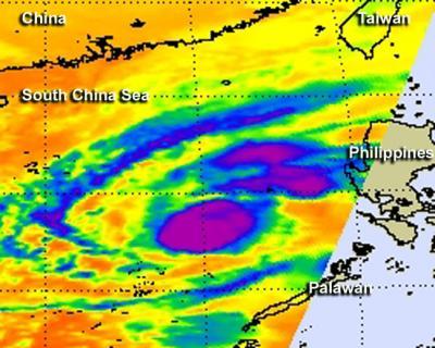
On Dec. 6 at 1:11 p.m. EST/U.S., NASA AIRS infrared data revealed the strongest thunderstorms (purple) within Typhoon Bopha surrounded the center of circulation and were in bands of thunderstorms north and northeast of the center, just skirting the west coast of Luzon, the northern Philippines. AIRS is an instrument that flies aboard NASA's Aqua satellite.
(Photo Credit: NASA JPL, Ed Olsen)
After Bopha loops over open ocean, it is expected to weaken and turn southwest after the weekend.
Source: NASA/Goddard Space Flight Center