An infrared look at Tropical Storm 18S by NASA's Aqua satellite revealed wind shear continues to take its toll on the storm and keeps pushing its main precipitation away from the center of the storm.
Wind shear is a major factor that can keep a tropical cyclone "down" or unable to consolidate and intensify because it keeps pounding the circulation of winds head on. Strong wind shear has been battering Tropical Cyclone 18S for a couple of days and is expected to continue the next couple of days.
On Feb. 26 at 1500 UTC (10 a.m. EST) Tropical Storm 18S was located about 1,000 nautical miles (1,151 miles/1,852 km) west-northwest of Learmonth, Australia, near 15.5 south and 98.0 east. TS18S still had maximum sustained winds near 35 knots (40.2 mph/64.8 kph) and was now moving to the south-southeast near 4 knots (4.6 mph/7.4 kph).
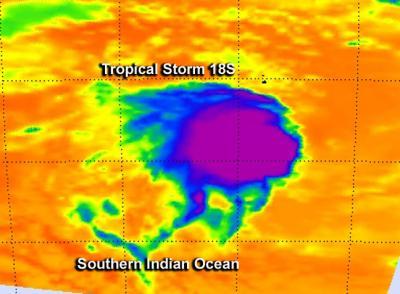
An infrared look at Tropical Storm 18S by the AIRS instrument on NASA's Aqua satellite on Feb. 26, revealed wind shear continues to take its toll on the storm and keeps pushing its strongest (purple) precipitation away from the center of the storm.
(Photo Credit: : NASA JPL, Ed Olsen)
Satellite imagery shows that the main convection and thunderstorms are still being pushed away from the center of circulation from wind shear. Vertical wind shear has also caused the storm to stretch out making it difficult to find the center on satellite imagery. According to the Joint Typhoon Warning Center (JTWC), an analysis of the upper level winds showed that the tropical storm is in an area of strong (30-40 knot/34.5 to 46.0 mph/55.5 to 74.0 kph) easterly vertical wind shear.
Tropical Storm 18S is expected to drift under weak steering conditions for the next two days after which time another weather system will push the storm eastward toward Western Australia.
Source: NASA/Goddard Space Flight Center