The thirteenth Tropical Depression of the Northwestern Pacific Ocean season didn't last long. In fact, Tropical Depression 13W lived for less than a day as a depression before fizzled.
TD13W was "born" at 1500 UTC/11 a.m. EDT on Aug. 17 with maximum sustained winds near 25 knots. Later that day at 2100 UTC/5 p.m. EDT, the Joint Typhoon Warning Center issued its final bulletin on the depression. At that time it was located near 28.0 north latitude and 126.0 east longitude, about 109 nautical miles northwest of Kadena Air Base, Japan.
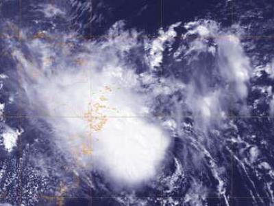
Before TD13W dissipated, the MODIS instrument that flies aboard NASA's Aqua satellite captured an image of the short-lived storm on Aug. 18 that showed the depression still had a circulation and thunderstorms around its center.
Before TD13W dissipated, NASA's Aqua satellite captured an image of the short-lived storm on Aug. 18 that showed the depression still had a circulation and thunderstorms around its center.
(Photo Credit: NRL/NASA)
On Sunday, Aug. 18, while Tropical Depression 12W had strengthened into Tropical Storm Trami, nearby Tropical Depression 13W had already weakened and by Aug. 19 became a remnant low pressure area. Trami was located to Tropical Depression 13W's southeast. Because TD13W was to Trami, the tropical storm basically took the life out of TD13W.
Source: NASA/Goddard Space Flight Center