The third tropical cyclone in the Southern Indian Ocean has been renamed Tropical Cyclone Claudia as NASA's Aqua satellite passed overhead.The AIRS instrument on Aqua captured infrared imagery of Claudia over two days that showed the western quadrant is most powerful part of the cyclone.
Aqua flew over Tropical Cyclone Claudia on Dec. 6 at 1959 UTC (2:59 p.m. EST/U.S.) and Dec. 7 at 0811 UTC (3:11 a.m. EST/U.S.). The Atmospheric Infrared Sounder (AIRS) instrument analyzes storms in infrared light, and revealed the temperatures of clouds and sea surface around the storm. On Dec. 6, the coldest cloud top temperatures (colder than -63F/-52C) were located in the northwestern quadrant of the storm. The next day, those strongest storms had shifted to the west and southwestern quadrants. The AIRS data on Dec. 7 also showed a much wider center of circulation, which was slightly exposed to outer winds. Thunderstorm development was also increasing around the center of circulation.
On Dec. 7 at 1500 UTC (10 a.m. EST), newly renamed Tropical Storm Claudia, formely Tropical Storm 03S had maximum sustained winds near 45 knots. Claudia was moving in a southerly direction and away from Diego Garcia. Claudia was centered near 14.3 south latitude and 75.4 east longitude, about 445 nautical miles south of Diego Garcia. Claudia is on a south-southwesterly track, but is expected to shift more to the south over the next several days.
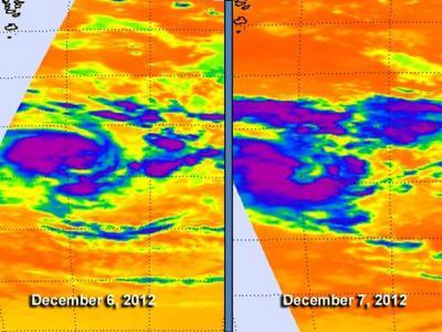
NASA's Aqua satellite flew over Tropical Cyclone Claudia on Dec. 6 at 2:59 p.m. EST/U.S. and Dec. 7 at 3:11 a.m. EST/U.S. The AIRS instrument showed the coldest, most powerful areas of the cyclone in purple, where cloud top temperatures exceeded 63F/-52C.
(Photo Credit: NASA JPL, Ed Olsen)
Claudia is currently in an area of moderate (10 to 20 knots) vertical wind shear and sea surface temperatures warm enough to keep it going. AIRS data indicates that sea surface temperatures were near 28 to 29 degrees Celsius.
Over the weekend of Dec. 8 and 9, however, Claudia will venture into cooler waters and the vertical wind shear is forecast to increase. Those two factors indicate that Claudia will weaken and become an extra-tropical storm over the weekend.
Source: NASA/Goddard Space Flight Center