Tropical Cyclone Colin continued moving through the Southern Indian Ocean on January 13 while NASA's TRMM satellite passed overhead and calculated the rates in which rain was falling throughout the storm.
The Tropical Rainfall Measuring Mission or TRMM satellite is managed by NASA and the Japan Aerospace Exploration Agency. TRMMM captured an image of rainfall rates occurring in Colin on Jan. 13 at 0753 UTC/2:53 a.m. EST. TRMM Precipitation Radar showed that the bulk of Colin's rainfall was west and south of the center and there were some isolated areas where rain was falling at a rate of up to 2 inches/50 mm per hour.
Tropical Cyclone Colin is the eighth tropical cyclone in the Southern Indian Ocean cyclone season this year. It also has a separate designation from La Reunion Island, where it is known as "06/2013/2014."
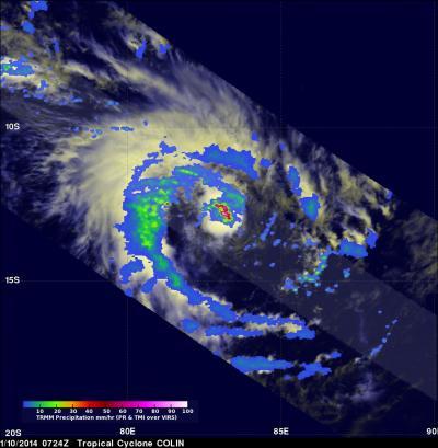
NASA's TRMM satellite captured an image of rainfall occurring in Tropical Cyclone Colin on Jan. 13 at 0753 UTC. The bulk of Colin's rainfall was west and south of the center.
(Photo Credit: NASA/JAXA/SSAI, Hal Pierce)
At 0900 UTC/4 a.m. EST on Jan. 13, Colin's maximum sustained winds were near 80 knots/148.2 kph/92.0 mph. Colin was located about 938 nautical miles/1,079 miles/1,737 km south of Diego Garcia, near 23.1 south and 75.0 east. Colin is moving to the south-southeast at 14 knots/16.1 mph/25.9 kph and over cooler sea surface temperatures that will cause it to weaken.
In addition to cooler sea surface temperatures, vertical wind shear is increasing as Colin tracks further south-southeast. Colin is expected to become extra-tropical in the next couple of days.
Source: NASA/Goddard Space Flight Center