Tropical Storm Toraji passed over Kyushu and transitioned into an extra-tropical storm while bringing heavy rainfall over the big island of Japan when NASA's Aqua satellite passed overhead on Sept. 4. The extra-tropical storm is now a cold-core system being carried by a frontal system.
The Atmospheric Infrared Sounder or AIRS instrument captured infrared data of Extra-Tropical Storm Toraji as it continued tracking through southern Japan on Sept.4 at 0429 UTC/12:29 a.m. EDT. AIRS showed that the coldest cloud top temperatures and strongest thunderstorms with heaviest rainfall stretched from Hyogo Prefecture in the southwest to Shiga Prefecture to Gifo Prefecture in the northeast.
At 1500 UTC/11 a.m. EDT on Sept. 4, Toraji had maximum sustained winds near 40 knots/46 mph/74 kph. It was centered near 32.7 north and 132.9 east, about 114 nautical miles/131 miles/211 km south of Iwakuni, Japan. Toraji has increased in forward speed over the last day and was moving to the northeast at 22 knots/25.3 mph/40.7 kph.
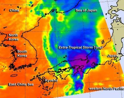
NASA's AIRS instrument data took this infrared image of Tropical Storm Toraji as it continued tracking through southern Japan on Sept. 4 at 0429 UTC. Purple indicate coldest cloud top temperatures and strongest thunderstorms with heaviest rainfall.
(Photo Credit: Image : NASA JPL/Ed Olsen)
The Joint Typhoon Warning Center's multi-level analyses indicated that Toraji is now an extra-tropical cold-core low pressure area, and it is linked to a fast moving frontal boundary. That frontal system is moving across Japan and will carry Toraji's energy with it.
Source: NASA/Goddard Space Flight Center