Boulder, Colo., USA – GSA Bulletin articles posted online between 2 October and 21 November span locations such as the San Andreas fault, California; Tibet; Mongolia; Maine; the Owyhee River, Oregon; the Afar Rift, Ethiopia; Wyoming; Argentina; the Sinai Peninsula, Egypt; British Columbia; the southern Rocky Mountains; Scandinavia; and Saturn's largest moon, Titan. Topics include the "big crisis" in the history of life on Earth; the structural geology of Mount St. Helens; and the evolution of a piggyback basin.
GSA Bulletin articles published ahead of print are online at http://gsabulletin.gsapubs.org/content/early/recent; abstracts are open-access at http://gsabulletin.gsapubs.org/. Representatives of the media may obtain complimentary copies of articles by contacting Kea Giles.
Sign up for pre-issue publication e-alerts at http://www.gsapubs.org/cgi/alerts for first access to new journal content as it is posted. Subscribe to RSS feeds at http://gsabulletin.gsapubs.org/rss/.
Please discuss articles of interest with the authors before publishing stories on their work, and please make reference to GSA Bulletin in your articles or blog posts. Contact Kea Giles for additional information or assistance.
Non-media requests for articles may be directed to GSA Sales and Service, gsaservice@geosociety.org.
The sediment budget of an alpine cirqueJohnny W. Sanders et al., Dept. of Earth and Planetary Science, University of California, Berkeley, California 94720, USA. Posted online 21 Nov. 2012; http://dx.doi.org/B33330.1.
Cirques are one of the most classic and common features found in alpine landscapes. And, although they are typically associated with glacial erosion, they owe much of their character to subaerial processes: Above the glacier, debris flows, avalanches, and rockfalls sculpt the headwall, while beyond the glacier, streams and sheetwash whisk away Muir's "mountain meal." In this work, Johnny W. Sanders and colleagues develop a sediment budget -- a framework that describes sediment sources and transport pathways in a region of interest -- for an alpine cirque in British Columbia, Canada. They then quantify the sediment budget terms at a cirque in the Canadian Rockies using field measurements and remote sensing techniques. Their results indicate the glacier is lowering its bed at about 0.5-0.9 mm per year. The subaerial headwall is backwearing at about 1.2 mm per year, but their data do not preclude a rate several times faster than this. These rates (Order 1 mm per year) are comparable to those measured at much larger glaciers and further confirm that cirque glaciers are fundamentally the same as their larger brethren, only smaller.
Late Cenozoic evolution of the Lunggar extensional basin, Tibet: Implications for basin growth and exhumation in hinterland plateausWilliam H. Woodruff Jr. et al. (Brian K. Horton, corresponding), Dept. of Geological Sciences, Jackson School of Geosciences, University of Texas at Austin, Austin, Texas 78712, USA. Posted online 21 November 2012; http://dx.doi.org/10.1130/B30664.1.
The Lunggar rift basin at 4.5 to 5 km elevation in west-central Tibet records the late Cenozoic history of east-west crustal extension within Earth's highest continental plateau. New sedimentologic, structural, and thermochronological data help define the depositional and exhumational history of the basin and the adjacent Lunggar range (5.5 to 6.5 km elevation), which has been uplifted during motion along a major low-angle normal fault. Sedimentary deposits and mapped structures are consistent with a shift from a closed lake basin to an externally drained fluvial system during a transition from an initial high-angle fault system that evolved into a low-angle fault during progressive extension. Low-temperature thermochronological data suggest that extension was underway by eight to ten million years ago, with late Miocene-Pliocene exhumation rates of roughly 1 km per million years. This rapid exhumation generated a conglomerate unroofing sequence and promoted rebound and erosional recycling of range-front basin fill along the central segment of the detachment fault. Collectively, the results presented here William H. Woodruff Jr. and colleagues support a model of rift evolution that invokes upper crustal thinning, supradetachment basin subsidence, and subsequent isostatic rebound along the more-evolved central segments of Tibetan extensional systems.
Reevaluation of the Piermont-Frontenac allochthon in the Upper Connecticut Valley: Restoration of a coherent Boundary Mountains-Bronson Hill stratigraphic sequenceDouglas W. Rankin et al., U.S. Geological Survey, Mail Stop 926a, National Center, Reston, Virginia 20192, USA. Posted online 21 Nov. 2012; http://dx.doi.org/10.1130/B30590.1.
The extent, mode, and time of emplacement of the large Piermont-Frontenac allochthon in the Boundary Mountains-Bronson Hill anticlinorium, New Hampshire-Vermont, USA are controversial. Silurian-Devonian rocks (formerly autochthonous pre-Middle Ordovician) were postulated to have been transported westward in the latest Silurian to Early Devonian as a soft- sediment gravity slide. New mapping and U-Pb geochronology do not support this interpretation. The proposed sole fault would place the allochthon over the inverted limb of a nappe, which includes the Emsian Littleton Formation. Mafic dikes (about 419 million years old) intrude previously folded strata attributed to the allochthon as well as the autochthonous Cambrian-Ordovician Albee Formation and Ordovician Ammonoosuc Volcanics. The 443-million-year-old Lost Nation pluton produces hornfels in previously deformed Albee. A 492-million-year-old tonalite intrudes the Albee, formerly interpreted as Silurian rocks of the allochthon. Silurian allochthonous rocks are restricted to a 25-square-kilometer klippe emplaced by hard rock thrusting in post-Emsian Devonian. Correlation along strikes to the northeast of the Albee with the Dead River Formation suggests that the Albee is of Ganderian affinity and that the Bronson hill magmatic arc in the Upper Connecticut Valley was built on Ganderian crust. Some of the pre-Silurian deformation in the Upper Connecticut Valley may be Penobscottian rather than Taconian.
The long-term topographic response of a continent adjacent to a hyperextended margin: A case study from ScandinaviaT.F. Redfield (corresponding) and P.T. Osmundsen, Geological Survey of Norway, N-7491 Trondheim, Norway. Posted online 21 November 2012; http://dx.doi.org/10.1130/B30691.1
Important advancements in our understanding of how continents break apart have been made throughout the past decade. Most recently it has been recognized that the story does not end with the beginning of sea floor spreading and the formation of oceanic crust. In this paper, T.F. Redfield and P.T. Osmundsen document "teleconnections," or far-field communications, between the faults that were responsible for pre-breakup crustal thinning and the landscapes that adorn the uplifted edge of today's Scandinavian continent. They show that the manner in which Scandinavian landscapes evolved (and continue evolving) was (and is) directly related to the width of the zone over which the crystalline continental crust was thinned. Although best exemplified by Scandinavia, the same interactions may be ongoing at many other passive margins around the world. Based on their observations, the Redfield and Osmundsen offer a hypothesis that links the onshore and offshore evolution of passive margins under a simple model invoking onshore erosion, offshore deposition, and the consequent isostatic adjustment of the continental edge to the progressively and continually changing vertical load. Because many passive margins host large hydrocarbon reservoirs and potential reserves, the hypothesis has significant implications for global petroleum systems. It also helps advance the understanding of how stretched continental lithosphere evolves through time, of why Norwegian large volume rockslide hazards come to exist, and perhaps may even clarify where the process of subduction eventually elects to commence.
Far-traveled latest Cretaceous-Paleocene conglomerates of the Southern Rocky Mountains, USA: Record of transient Laramide tectonismPaul L. Heller et al., Dept. of Geology and Geophysics, University of Wyoming, Laramie, Wyoming 82071, USA. Posted online 21 November 2012; http://dx.doi.org/10.1130/B30699.1
A solitary, widespread conglomerate deposited between 70 and 60 million years ago is found in various basins of Utah, Colorado, and New Mexico, USA. The river-laid deposits are unusual compared to most conglomerates associated with faulted mountain ranges because they are stratigraphically quite thin, but they are broadly found over many tens of kilometers across the Uinta, Piceance Creek, and San Juan basins and in southwest Utah. Each of the units came from separate source areas across the region. Similar widespread conglomerate units of this age are apparently absent in other Rocky Mountain basins. The distribution, timing, and dispersion directions of these far-travelled deposits are most consistent with the previously hypothesized passage of a thick piece of oceanic crust that collided against North America about 90 million years ago and then moved by plate tectonic forces underneath the western half of the continent. This oceanic plateau would have passed beneath the southern Rocky Mountains during the time of deposition of the gravel units. Vertical movement of North America would have resulted from the passage of this feature in the underlying mantle. As such, Paul L. Heller and colleagues suggest that these deposits record the migration of an oceanic plateau beneath the Rocky Mountain region.
Faulting within the Mount St. Helens conduit and implications for volcanic earthquakesJohn S. Pallister et al., Volcano Disaster Assistance Program, U.S. Geological Survey Cascades Volcano Observatory, Vancouver, Washington 99683, USA. Posted online 21 November 2012; http://dx.doi.org/10.1130/B30716.1.
This paper by John S. Pallister and colleagues describes the structural geology of a remarkably well-exposed cylindrical fault zone that surrounded lava spines at Mount St. Helens and possible relationships between faulting and volcanic earthquakes during the 2004-2008 eruption of Mount St. Helens.
Tertiary basin evolution along the northeastern margin of the Tibetan Plateau: Evidence for basin formation during Oligocene transtensionWeitao Wang et al., State Key Laboratory of Earthquake Dynamics, Institute of Geology, China Earthquake Administration, Beijing 100029, China. Posted online 21 November 2012; http://dx.doi.org/10.1130/B30611.1
As one of the Cenozoic basins in the remote northern Tibet margin, the southern Ningxia basin encodes much information about the northward growth history of the Tibetan Plateau and the related climate change. Weitao Wang and colleagues use a combination of field and subsurface observations to constrain basin evolution from the Middle Tertiary through Quaternary time. The results suggest that basin formation occurred about 30 million years ago and was characterized by extensional accommodation space along northern basin-bounding faults. Basin inversion initiated between six and 10 million years ago, associated with development of the modern northern Tibet boundary fault. These phenomena imply that the onset of Cenozoic sedimentation in the southern Ningxia basin does not represent a developing foredeep associated with northward growing Plateau in the latest Eocene, but rather reflects transtensional deformation, inboard of extensional basins along the east Asian margin.
U-Pb zircon geochronology of major lithologic units in the eastern Himalaya: Implications for the origin and assembly of Himalayan rocksA. Alexander. G. Webb et al., Department of Geology and Geophysics, Louisiana State University, Baton Rouge, LA 70803, USA. Posted online 21 November 2012; http://dx.doi.org/10.1130/B30626.1.
Recent investigations of Himalayan geology suggest that simple questions -- such as "Where does Himalayan material originate?" and "How has Himalayan material been assembled?" -- may have remarkably complex answers. Authors Webb, Yin, and Dubey address these questions across the eastern Himalaya by collecting field-based and analytical data (principally, zircon crystallization ages). Their results demonstrate that the Himalayan mountains are dominantly comprised of rocks scraped off of India, but that some of these rocks contain sediment originally derived from a northern microcontinent (the Lhasa terrane) that rifted away from India in the Late Triassic. The new field and age constraints are consistent with models of Cenozoic mountain-building involving emplacement of Himalayan crystalline rocks at depth, without significant fault-bound extrusion to the surface. These findings are synthesized in a new kinematic model for the evolution of the Eastern Himalaya from the Late Triassic to the Late Cenozoic.
Fluvial features on Titan: Insights from morphology and modelingDevon M. Burr et al., Earth and Planetary Sciences Dept., University of Tennessee, 1412 Circle Drive, Knoxville TN 37996-1410, USA. Posted online 21 November 2012; http://dx.doi.org/10.1130/B30612.1.
At a distance of 10AU from the Sun, Titan, the largest satellite of Saturn, is a cold, frozen echo of an abiotic Earth. Like Earth, Titan has a thick, nitrogen-rich atmosphere that actively cycles volatiles, resulting in a wide range of fluvial morphologies. Unlike on Earth, the materials that formed these Titan features consist of flowing liquid hydrocarbons transporting water ice or organic sediments. Prior first-order modeling shows the similarity of fluvial erosion and transport processes on the two bodies, despite such disparate materials and conditions, enabling these fluvial features to be understood through terrestrial analogy and modeling. In performing such work, Devon Burr and colleagues conclude that network patterns and reach-scale morphologies imply a range of terrestrial-style influences on channelized flow. Inter-comparison of data from the Cassini-Huygens mission implies that dissection of Titan uplands covers an order of magnitude more area than previously estimated. With appropriate parameters, terrestrial hydraulic equations are applicable to flow on Titan for turbulent conditions and rough boundaries. The resultant sediment movement and bedform development should occur at lower bed shear stress. Overall, observations show that Titan, like Earth, is a world pervasively influenced by fluvial processes, for which appropriate terrestrial analogs and formulations provide insight.
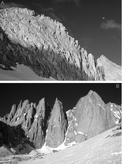
This photo shows Mount Conness, Sierra Nevada, Calif. (top); Mount Whitney, Sierra Nevada, Calif. (bottom).See the related paper, "The sediment budget of an alpine cirque," by Johnny W. Sanders and colleagues.
(Photo Credit: Johnny W. Sanders and colleagues; GSA Bulletin, 2012.)
Pre-Mesozoic Alpine basements -- Their place in the European Paleozoic frameworkJürgen F. von Raumer et al., Département de Géosciences, Université de Fribourg, 6, Chemin du Musée, CH-1700 Fribourg, Switzerland. Posted online 31 October 2012; http://dx.doi.org/10.1130/B30654.1.
Most of the present-day continents were assembled about 300 million years ago, in the mega continent Pangea, containing the pieces of older mountain chains and having resulted from the continuous transformation of Earth's crust during hundreds of million years in the past. During their long-lasting growth, the Appalachians and the Variscan European mountain chains were the place of large-scale transformations, reducing the former basement areas assembled in Pangea into smaller pieces through vertical and horizontal movements obeying the long-term crustal deformations imposed by the migration of continents. One of the major stages of these transformations led to the formation of the Alpine mountain chain, about 100-million-years ago, resulting from the collision of the African continent with Europe. The giant mountain-puzzle of the Alps have been the subject of geological investigations for more than 200 years. This paper by Jürgen F. von Raumer and colleagues tries to reconstruct the evolution for the time span between 500 million (Cambrian) to 300 million years (Permian, Pangea stage), to better integrate its puzzle stones into the worldwide Alleghenian-Variscan mountain belt comprising the Appalachians and the European and Asian Variscan mountain chains.
Low rates of bedrock outcrop erosion in the central Appalachian Mountains inferred from in situ 10BeEric W. Portenga et al., School of Geographical and Earth Science, University of Glasgow, Glasgow G12 8QQ, Scotland, UK, and Department of Environment and Geography, Macquarie University, North Ryde, NSW, Australia. Posted online 31 October 2012; http://dx.doi.org/10.1130/B30559.1.
Bedrock outcrops in the central Appalachian Mountains make up ridgelines that define watershed boundaries and thus influence landscape evolution. However, erosion rates of these rock exposures are poorly constrained over the course of thousands of years. Samples from over 70 outcrops were collected and concentrations of the isotope, 10-Beryllium, were measured to determine the amount of time the rock material has been exposed at Earth's surface before being eroded away. The spatial patterns of erosion were also analyzed in an effort to understand how different parts of the varied landscape are evolving through time. Eric Portenga and colleagues find that bedrock ridgelines are eroding on average at nine meters per million years -- a rate slower than river drainage-basins in the Susquehanna and Potomac River watersheds. Our findings suggest that the central Appalachian landscape is in disequilibrium and still adjusting to hydrological changes. The presented erosion rates are similar, though, to denudation rates determined by other means indicating that the pace of landscape evolution in the central Appalachian Mountains is slow, and has been since the rifting of the supercontinent, Pangaea.
A century of U-Pb geochronology: The long quest towards concordanceF. Corfu, University of Oslo, Dept. of Geosciences, Postbox 1047 Blindern, N-0316 Oslo, Norway. Posted online 31 October 2012; http://dx.doi.org/10.1130/B30698.1.
The uranium-lead method for dating rocks and minerals is based on the radioactive decay of 238U to 206Pb and 235U to 207Pb. Trace amounts of uranium are incorporated in minerals such as zircon at the time of their formation. Geochronologists separate such minerals and determine the amounts and isotopic compositions of U and Pb, using them to calculate the age of the minerals. The method has been under development for the past century and has become the most widely used geochronological tool. This paper by F. Corfu reviews the most salient developments in the modern history of the method, focusing especially on one important factor which complicates its application. This is the fact that some minerals, especially zircon, often reveal some discrepancies between the U-Pb ages obtained by the two decay systems. The main reasons for the discordance are generally partial loss of lead or mixing of multi age components, but there are also other factors. Much of the development of U-Pb geochronology has been devoted to the search and testing of techniques and approaches on how to eliminate the discordance. We have now come a long way towards a solution of the problem, but many challenges remain.
Submarine slope processes in rift-margin basins, Miocene Suez Rift, EgyptLorna J. Strachan et al., School of Earth, Environment & Atmospheric Sciences, University of Manchester, Manchester, M13 9PL, UK. Posted online 31 October 2012; http://dx.doi.org/10.1130/B30665.1.
Submarine rift basins are prominent features on Earth's surface that provide insight to plate tectonics and contain important economic deposits. This study by Lorna J. Strachan and colleagues of ancient (Miocene) strata in the Sinai Peninsula, Egypt, reveals the complexity of sediment transport and deposition in an actively-rifting submarine basin. The research focuses on rift-margin basin evolution immediately adjacent to rift-bounding faults. Erosion and transport on the steep rift margin resulted in deposits built from energetic coalescing channelized gravity-flow deposits. Contemporaneous tectonic events modified seafloor relief, changing the pathways of sediment flows with time resulting in a complex basin fill. The seafloor was dominated by very coarse-grained sediments -- some as large as houses -- that were sourced from steep slopes, a multitude of rivers, and small deltas. In comparison with other submarine rift-margin-basins globally, Strachan and colleagues found little commonality in vertical sedimentary trends -- a testament to the wide variety of sub-environments and flow processes, and their response to coeval tectonic and paleoclimatic events
The continental record and the generation of continental crustP.A. Cawood et al., Dept. of Earth Sciences, University of St. Andrews, North Street, St. Andrews KY16 9AL, UK. Posted online 31 October 2012; http://dx.doi.org/10.1130/B30722.1.
Continental crust is the archive of Earth's history. It is characterized by peaks of crystallization ages are that linked to the timing of the assembly of supercontinents. These peaks of ages reflect a tectonic bias because igneous and metamorphic rocks generated in late stage convergence and collision zones are most likely to be preserved, rather than fundamental pulses of magmatic activity. New analysis of the isotope ratios in the mineral zircon, which occurs as fragments in sedimentary rocks, suggests that at least ~60%-70% of the present volume of the continental crust had been generated by three billion years ago. These data show that growth of continental crust was continuous rather than episodic, and there was a marked decrease in the rate of crustal growth at about three billion years ago that may have been linked to the onset of significant crustal recycling, probably though subduction at convergent plate margins. The 60%-70% of the present volume of the continental crust estimated to have been present three billion years ago, contrasts markedly with less than 10% of crust of that age apparently still preserved. Large volumes of crust and subcontinental mantle lithosphere have therefore been recycled back into the mantle through processes such as subduction and delamination.
Magmatic history of Dabbahu, a composite volcano in the Afar Rift, EthiopiaL. Field et al., School of Earth Sciences, University of Bristol, Wills Memorial Building, Queen's Road, Bristol, BS8 1RJ, UK. Posted online 25 October 2012; http://dx.doi.org/10.1130/B30560.1.
Dabbahu is a volcano in northern Ethiopia that comprises a range of lavas from basaltic to very evolved rhyolites which have a high silica content. L. Field and colleagues present 93 new whole-rock analyses, mineral analyses from 65 samples and 9 new 40Ar/39Ar dates, together with a new geological map of the volcano. They use these data to show that Dabbahu has been active for over 67 thousand years, but there is an apparent hiatus of about 20 thousand years in its eruptive history that occurred between the eruption of the most evolved magmas. Some rhyolites erupted both effusively and explosively. All magmas were erupted from a relatively closely spaced network of vents and fissures, and field evidence indicates that magmas were not erupted in a simple fractionation sequence. Some mixing occurred between magmas of less evolved compositions, together with more evolved compositions shortly prior to, or during, eruption. The differentiation of basalt to rhyolite must have occurred on timescales that were relatively short compared to the lifetime of the volcano, probably due to the small volumes of basalt intruded into the crust and consequently enhanced cooling and crystallization rates. A network of stacked sills or closely spaced dykes in the shallow to mid crust represents the most plausible configuration of the sub-volcanic plumbing system. Input of new magma batches into such a system may serve as a key eruption trigger at Dabbahu.
Basin-scale cyclostratigraphy of the Green River Formation, WyomingW. Aswasereelert et al., Department of Geoscience, University of Wisconsin, 1215 West Dayton Street, Madison, Wisconsin 53706, USA. Posted online 25 October 2012; http://dx.doi.org/10.1130/B30541.1.
The Green River Formation was deposited by "great lakes" that occupied parts of Wyoming, Colorado, and Utah during the Eocene epoch from about 53 to 44 million years ago. These lakes deposited a richly detailed stratigraphic record of climate change, corresponding to the most geologically recent period of warm climate. Their record may thus provide valuable insights into the behavior of future global warming, provided geoscientists can precisely measure rates and mechanisms of Eocene environmental change. W. Aswasereelert and colleagues present an innovative new way of doing so, by combining previously published radioisotopic dates from volcanic ash that fell into the lakes with a new technique called macrostratigraphy, which rigorously synthesizes outcrop and core data from multiple locations. Unlike previous studies, this approach avoids the need to assume an age model a priori, a practice that can lead to circular reasoning. Based on spectral analysis of macrostratigraphic time series, Aswasereelert and colleagues have discovered a strong 100,000 periodicity in the alternation of lake versus river deposits, which has effectively imprinted a high-resolution "calendar" directly on the rocks. These results suggest that even finer time resolution may be possible and also demonstrate the broader effectiveness of macrostratigraphy in quantifying cyclic sedimentation.
Reactivation of the Archean-Proterozoic suture along the southern margin of Laurentia during the Mazatzal orogeny: Petrogenesis and tectonic implications of ca. 1.63 Ga granite in southeastern WyomingDaniel S. Jones et al., Dept. of Geosciences, Western Carolina University, Cullowhee, NC 28723, USA. Posted online 25 October 2012; http://dx.doi.org/10.1130/B30577.1.
A major suture exists in North America between largely Archean rocks (older than 2.5 billion years) and younger Paleoproterozoic rocks (between 1.6 and 2.5 billion years old), running approximately from northern Utah to the Great Lakes region. The suturing, generally interpreted as reflecting the accretion of one or more island arcs to the Laurentian continent, took place approximately 1.80 to 1.74 billion years ago. The suture region remained stable for about 100 million years as the continent grew and plate tectonic activity shifted southward. Work by Daniel S. Jones and colleagues shows that around 1.65 billion years ago a segment of this suture was reactivated in the Sierra Madre of southern Wyoming in response to compressional events far to the south. This reactivation caused the crust near the suture to thicken and eventually melt, producing 1.63-billion-year-old granite. Building on other studies, Jones and colleagues suggest that the entire transcontinental Archean-Paleoproterozoic suture remained a line of mechanical weakness long after it became interior to the Laurentian plate and that it was reactivated along its length during the Mazatzal orogeny approximately 1.65 billion years ago.
Predicting grain size in gravel-bedded rivers using digital elevation models: Application to three Maine watershedsNoah P. Snyder et al., Earth and Environmental Sciences Dept., Boston College, 140 Commonwealth Ave., Chestnut Hill, MA 02467, USA. Posted online 25 October 2012; http://dx.doi.org/10.1130/B30694.1
River bed grain size -- from tiny particles of sand to gravel and boulders -- plays a crucial role in establishing habitat for many threatened fish species. Searching for a way to better identify habitat suitable for restoration projects, researchers from Boston College and Indiana University found a way to reliably predict grain size based on channel properties measured from digital topographic data. Using high-resolution laser topographic surveys of three Maine river systems, the team found that the three predictive models tested were 70%-80% accurate, with the best results in rivers with coarse gravel beds. The authors explore how glacial and land-use history influences channel processes in the rivers, and its impact on model success or failure. The team found its methods most successful in areas downstream of lakes where sediment spills into the channels mostly from the adjacent riverbanks and hillsides. The models were less successful in places where larger amounts of sediment are supplied from an upstream network of creeks and tributaries. By giving researchers a new tool to identify rivers and streams most suitable for desired species of fish, the models tested by the team offer researchers a new method to prioritize fish habitat restoration projects.
Owyhee River intracanyon lava flows: Does the river give a dam?Lisa L. Ely et al., Dept. of Geological Sciences, Central Washington University, 400 E. University Way Ellensburg, WA 98926, USA. Posted online 2 Oct. 2012; http://dx.doi.org/10.1130/B30574.1.
Rivers in bedrock canyons are occasionally dammed by lava flows or large mass movements, which can dominate the river behavior and landscape for many kilometers. Lisa L. Ely and colleagues use examples from the Owyhee River in southeastern Oregon to document the effects of lava dams on rivers at a variety of spatial and temporal scales. Lava flows have flowed over the rim of the Owyhee Canyon and dammed the river six times in the last two million years, most recently only 70,000 years ago. These lava dams blocked the river for tens of thousands of years, and the lakes behind them had to fill with sediment before the river was able to transport sand and gravel over the dam crest and carve through the dams. Once incision through the dams began, it was several times greater than the average long-term rate of canyon formation. The resulting landscape of flat, broad lava layers capping steep cliffs of softer sediment is conducive to landslides, some of which in turn dammed the river and produced large floods when the dams failed. Thus, well beyond the lifetime of the lava dams, the lava flows indirectly continue to affect the river canyon landscape.
U-Pb (zircon) age constraints on the timing and duration of Wenlock (Silurian) paleocommunity collapse and recovery during the "Big Crisis"Bradley D. Cramer et al., Kansas Geological Survey/Dept. of Geology, University of Kansas, Lawrence, Kansas 66047, USA. Posted online 2 October 2012; http://dx.doi.org/10.1130/B30642.1.
The history of life on Earth is recorded in the stratigraphic record. Stated another way, the rocks that make up the Earth itself are a book that contains the story of our planet's tumultuous history. The interactions between climate, biology, the oceans, and the atmosphere are all preserved in the rock record, and it is the job of geoscientists to decipher these events. As expected, however, deciphering this history gets increasingly complex the further back in time one chooses to look. A particularly large stumbling block to the study of Earth history in deep time (many hundreds of millions of years ago) has traditionally been our inability to determine precise and reliable dates and durations of ancient global change events. Bradley D. Cramer of the Kansas Geological Survey and colleagues combine a series of recent advances in analytical chemistry together with recent advances in how geoscientists integrate multiple types of data together. The result is a demonstration that the ancient history of the Earth can now begin to be studied at a resolution and with a level of precision that had been previously considered impractical, impossible, or both.
Latest Pleistocene and Holocene slip rate for the San Bernardino strand of the San Andreas fault, Plunge Creek, Southern California: Implications for strain partitioning within the southern San Andreas fault system for the last ~35 k.y.Sally F. McGill et al., Dept. of Geological Sciences, California State University, San Bernardino, 5500 University Parkway, San Bernardino, California 92407-2397, USA. Posted online 2 October 2012; http://dx.doi.org/10.1130/B30647.1.
This study by Sandy McGill and colleagues presents a new slip-rate measurement for the San Andreas fault in the San Bernardino Valley of southern California. Two different geologic features, a ~35,000-year-old channel wall and a 10,500-year-old alluvial fan, are each offset by the fault by amounts that indicate a long-term average slip rate of 7-16 mm per year for the San Bernardino strand of the San Andreas fault. This is significantly slower than previously inferred for this section of the San Andreas fault. These results suggest that the amount of slip transferred from the Mojave section of the San Andreas fault to the San Jacinto fault may be greater than previously inferred. The new, lower, long-term slip-rate estimate is close to but somewhat faster than geodetic estimates of the rate at which tectonic plates are currently bending across the San Andreas fault.
Gobi-Tianshan connections: Field observations and isotopes from an early Permian arc complex in southern MongoliaR.C. Economos et al., University of Southern California, Los Angeles, CA 90089, USA. Posted online 2 October 2012; http://dx.doi.org/10.1130/B30324.1.
The Central Asian Orogenic belt, which stretches across southern Mongolia and Northern China, is constructed of volcanic arcs and intervening basins that were generated by the consumption of the Paleo-Asian Ocean. This belt is of interest to the igneous petrology community because of the diversity of its magmatic components and their exhumation during final amalgamation of the northern part of the Asian continent. The age and nature of this structural amalgamation are both matters of significant controversy. R.C. Economos and colleagues investigated the Gobi-Tianshan Intrusive Complex, an igneous complex generated as part of this final closure, via U-Pb geochronology, isotope geochemistry, and detailed field mapping. Geochronology shows the complex to be Early Permian in age, and isotope geochemistry ties it to a far-reaching belt of isotopically unusual plutons with the same age and basic petrological characteristics. We argue that the Gobi-Tianshan Intrusive Complex and these similar plutons were generated in a subduction zone setting in which their isotopes were disrupted by the subduction of sedimentary material. Thus, the study area marks the final subduction in the Central Asian Orogenic Belt and was immediately post-dated by a major shift in tectonic regime.
Drainage and base-level adjustments during evolution of a late Pleistocene piggyback basin, Eastern Cordillera, Central Andes of northwestern ArgentinaGustavo González Bonorino and Liliana del Valle Abascal, CONICET-CADIC, UTN-FRRG, B. Houssay 200, Ushuaia, CP9410, Argentina. Posted online 2 October 2012; http://dx.doi.org/10.1130/B30395.1.
Quaternary uplift of an orogenic barrier in the Andean foothills in NW Argentina, South America, partly obstructed eastward flowing streams and gave rise to a narrow intramontane basin extending 110 km, with a north-south trend. In the northern sector of the basin, streams initially were competent to carve their channels across the rising barrier, but most were later defeated and deflected. However, the deflected water courses collected their discharges into a trunk stream which, thus reinforced, was able to maintain open a water gap that incised 800 m into basement rocks underlying the barrier. In contrast, in the southern reach of the basin, streams were fully contained by the barrier, and their discharges gave rise to a lake that grew in extent until water level reached a spillover point across the barrier; backward erosion followed and the lake waters were drained. The disparate fluvial behavior is attributed to a combination of areally varying rainfall depth, rain shadowing by the rising barrier, and the indirect influence of inherited basement structures in the basin geometry and river channel gradients. A relative time scale for these events is constructed employing techniques and concepts of geomorphology.
Oligocene regional denudation of the northern Afar dome: Pre- and syn-breakup stages of the Afro-Arabian plateY. Anvi et al., Geological Survey of Israel, 30 Malkhe Israel Street, Jerusalem 95501, Israel. Posted online 2 October 2012; http://dx.doi.org/10.1130/B30634.1.
This paper by Y. Anvi and colleagues highlights the critical role played by a regional truncation (erosive) surface (RTS) developed during the Oligocene (between about 31 and 26 million years ago) in the northeastern Afro-Arabian continent. This vast and flat erosional surface developed during the formation of a ~3000 by 1500-km crustal doming above the Afar mantle plume and widespread fluvial erosion that truncated this dome. The RTS separates two principal clastic units that, together with the reconstructed geological features below it, define three principal tectonic phases during the beginning of the Afro-Arabian breakup: (1) Middle Eocene-Early Oligocene pre-Red Sea rifting intraformational monomictic (single component) conglomerates preserved below the RTS; (2) an Oligocene development of the RTS by slow crustal updoming caused by the upwelling of the Afar mantle plume, associated by large scale erosion in similar rate; and (3) post-RTS Late Oligocene-Early Miocene rifting of the Red Sea and Suez, including the initiation of the Dead Sea transform plate boundary. This phase has been associated by intensive deposition of syn-tectonic polymictic (multiple components) conglomerates. This three-stage model indicates the mutual genetic relationship between the Early Oligocene penetration of the Afar plume and the post Oligocene rifting and continental breakup of the Afro-Arabian continent.
Source: Geological Society of America