SAN FRANCISCO, October 30, 2013 -- A scientist from Cologne University has used Google's online street view scans to document the damage caused by the 2009 L'Aquila earthquake and suggests that the database would be a useful tool for surveying damage caused by future earthquakes. The findings are published in the November issue of the Seismological Research Letters.
The magnitude 6.3 2009 L'Aquila earthquake in the Italian Abruzzi Mountains caused widespread damage in the city and surrounding villages.
In 2011 Klaus-G. Hinzen, a seismologist with Cologne University in Germany, and colleagues from Italy conducted a field survey, taking 3D laser scans to document earthquake rotated objects. Later Hinzen used Google Earth software to map the exact locations of numerous photos of damaged constructions and when consulting Google street views, discovered the scans had been taken less than one year before the earthquake, providing an unexpected opportunity to compare the locations captured by the 2011 photos with Google street view scans.
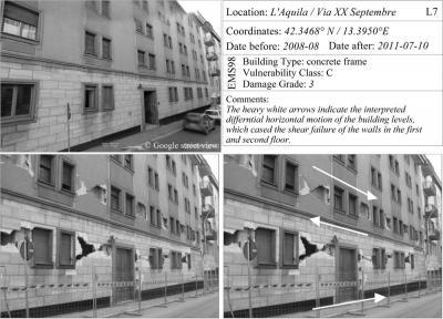
These images use Google street view scans to identify quake-related damage.
(Photo Credit: K-G Hinzen/SRL)
Google Earth's aerial views have helped capture an overview of damage to L'Aquila and specific collapsed structures. But the Google street views show the details – fractures, plaster breaks and collapsed walls. The scans help identify the damage caused by the quake rather than a lack of building maintenance or disrepair.
Hinzen suggests that any planned systematic survey of earthquake damage could benefit from the use of Google street view, if available for the area under investigation.
Source: Seismological Society of America