Emily is now a surface trough or elongated area of low pressure. The National Hurricane Center noted that Emily's remnants contain a large area of cloudiness and thunderstorms extending from eastern Cuba northeastward across the southeastern Bahamas.
There's a good chance that Emily can make a comeback and get her act together on the weekend as upper-level winds become more favorable. The National Hurricane Center gives Emily a 60% chance of making that comeback over the weekend.

GOES-13 satellite imagery in 15 minute intervals from Aug. 3 at 15:15 UTC (11:15 a.m. EDT) to August 8 and shows Emily forming east of Hispaniola (bottom right) and moving west over the Dominican Republic, Haiti and eastern Cuba.
(Photo Credit: NASA/NOAA GOES Project, Dennis Chesters)
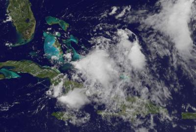
This visible image of Emily's remnant clouds was taken from the GOES-13 satellite on Aug. 5 at 16:01 UTC (12:01 p.m. EDT) just north of the eastern tip of Cuba. Higher thunderstorms in the center are casting small shadows on the lower, less powerful thunderstorms around them.
(Photo Credit: NASA/NOAA GOES Project, Dennis Chesters)
Source: NASA/Goddard Space Flight Center