Once a typhoon now an extra-tropical cyclone in the far northern Pacific Ocean, Lekima is weakening over cool waters. NASA's Aqua satellite captured the last image of Lekima as a typhoon before it weakened.
On Oct. 25 at 03:20 UTC, the Moderate Resolution Imaging Spectroradiometer or MODIS instrument aboard NASA's Aqua satellite captured a visible image of Typhoon Lekima in the northwestern Pacific Ocean. It was the second to last day that Lekima held onto typhoon status before weakening to an extra-tropical storm. The image showed that Lekima still maintained an eye, although it was filling in with clouds. At the time of the MODIS image, bands of thunderstorms still wrapped tightly around the center of circulation.
On Saturday, Oct. 26 the Joint Typhoon Warning Center issued its final warning on Typhoon Lekima as it headed northeast into the cooler waters of the northern Pacific Ocean.
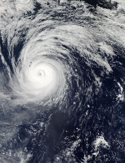
On Oct. 25 at 03:20 UTC, the MODIS instrument aboard NASA's Aqua satellite captured this visible image of Typhoon Lekima in the northwestern Pacific Ocean, the second to last day that it was at typhoon status before weakening.
(Photo Credit: Image : NASA Goddard MODIS Rapid Response Team)
At 0900 UTC/5 a.m. EDT on Oct. 26, Lekima was still a typhoon with maximum sustained winds near 70 knots/80.5 mph/129.6 kph, but the winds were quickly waning. Lekima was located near 36.9 north latitude and 152.4 east longitude, about 565 nautical miles/650.2 miles/ 1.046 km east-southeast of Misawa, Japan. Lekima was transitioning into an extra-tropical, cold core low pressure area and speeding northeast at 39 knots/44.8 mph/72.2 kph.
As Lekima continued weakening the storm expanded. On Oct. 26 at 0900 UTC, tropical storm-force winds extended 210 nautical miles/241.7 miles/388.7 km from the center, making the storm as wide as 420 nautical miles/483.3 miles/777.7 km in diameter. Lekima was a weakening cold-core low pressure area on Oct. 28.
Source: NASA/Goddard Space Flight Center