Cyclone Imelda reached hurricane strength on April 14 and its eye "opened" and became apparent on visible imagery on imagery from NASA's Aqua satellite. By April 15, the eye had "closed" and become filled in with clouds.
When NASA's Aqua satellite passed over Tropical Cyclone Imelda on April 14 at 0955 UTC (5:55 a.m. EDT), the Moderate Resolution Imaging Spectroradiometer (MODIS) instrument aboard captured a visible image that clearly showed the eye of the storm. The image was created by the MODIS Rapid Response Team at NASA's Goddard Space Flight Center in Greenbelt, Md.
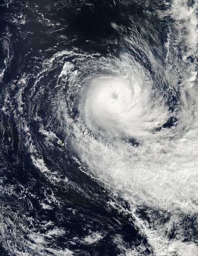
NASA's Aqua satellite passed over Tropical Cyclone Imelda on April 14 at 5:55 a.m. EDT. Aqua captured this visible image that clearly shows the eye of the storm. La Reunion Island is left of the storm.
(Photo Credit: : NASA Goddard MODIS Rapid Response Team)
On April 15 at 0615 UTC (2:15 a.m. EDT), MODIS captured another image of Imelda and the storm's eye appeared "closed." The eye had actually become filled in with a large cold dense overcast (clouds). The storm also appeared to be somewhat elongated from west to east.
On April 15 at 0900 UTC (5 a.m. EDT), Imelda's maximum sustained winds were near 65 knots (75 mph/120.4 kph). Imelda's center was located near 19.8 south latitude and 61.9 east longitude, about 360 nautical miles (414.3 miles/666.7 kph) east-northeast of La Reunion Island. Imelda is moving south at 9 knots (10.3 mph/ 16.6 kph).
Microwave satellite imagery from the AMSU-B instrument on NOAA's polar orbiting satellite showed that the convection around the low-level center is weakening. Forecasters at the Joint Typhoon Warning Center expect that Imelda will continue to weak as wind shear continues to increase (which is causing the storm to elongate).
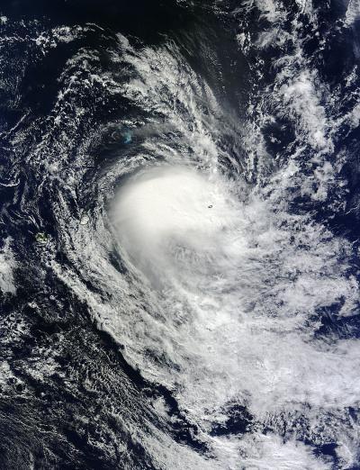
NASA's Aqua satellite passed over Tropical Cyclone Imelda on April 15 at 2:15 a.m. EDT. Aqua captured this visible image that showed Imelda's eye had filled in with clouds and the storm appears to be elongating.
(Photo Credit: : NASA Goddard MODIS Rapid Response Team)
Source: NASA/Goddard Space Flight Center