Forecasters at the Joint Typhoon Warning Center were keeping a close eye on a low pressure area known as System 94S yesterday, and satellite data helped confirm that today it has strengthened into Tropical Storm Bingiza.
The Moderate Resolution Imaging Spectroradiometer (MODIS) instrument aboard NASA's Terra satellite captured this image of Tropical Storm Bingiza at 06:30 UTC (1:30 a.m. EST) on its approach to Madagascar. The highest, strongest thunderstorms appeared almost bubble-like near the center of the storm's circulation.
The Tropical Rainfall Measuring Mission (TRMM) Satellite also flew over the storm and using microwave data and precipitation radar measured the rainfall rates happening throughout the storm.
TRMM captured the rainfall rates of Tropical Storm Bingiza on Feb. 10 at 06:39 UTC (1:39 a.m. EST). A precipitation analysis from TRMM's Microwave Imager (TMI) and Precipitation Radar (PR) data shows that the intensifying storm had a fairly large area of moderate rainfall, falling at a rate between .78 to 1.57 inches (20 to 40 mm) per hour. The rainfall appeared to be around the entire storm with the exception of the south and southeastern quadrants.
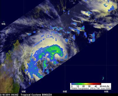
NASA and JAXA's TRMM satellite captured the rainfall rates of Tropical Storm Bingiza on Feb. 10 at 06:39 UTC (1:39 a.m. EST). The rainfall appears to be around the entire storm with the exception of the south and southeastern quadrants. The yellow and green areas indicate moderate rainfall between .78 to 1.57 inches per hour. Red areas are heavy rainfall at almost 2 inches per hour.
(Photo Credit: NASA/SSAI, Hal Pierce)
Multispectral satellite imagery shows that the low-level circulation center is well-defined. There is also strong convection wrapping around the northern edge of the center, which is where TRMM saw most of the rainfall occurring.
At 0900 UTC (4 a.m. EST) on Feb. 10, Tropical Storm Bingiza had maximum sustained winds near 45 knots (52 mph/83 kmh). It was about 460 miles (740 km) north of La Reunion, near 13.6 South and 54.4 East. It was creeping slowing to the northwest near 1 knot (1 mph/2 kmh).
Tropical Storm Bingiza is intensifying slowly and is expected to meander slowly over the next couple of days. Over the weekend, Bingiza is expected to move southwest once a sub-tropical ridge (elongated area) of high pressure builds in. It is also forecast to strengthen and move toward central Madagascar. Currently a landfall is not expected until early next week in central Madagascar.
Source: NASA/Goddard Space Flight Center