At NASA's Goddard Space Flight Center in Greenbelt, Maryland, TRMM's Precipitation Radar data were also used to construct a simulated 3-D view of 92B's rainfall structure looking toward the east from India. TRMM PR pulled away a veil of clouds and revealed that some powerful convective storm tops were reaching heights of almost 17 km (about 10.5 miles). The extreme rainfall in this area was returning radar reflectivity values of over 53.7 dBZ to the TRMM satellite.
On May 22 at 7:11 UTC/3:11 a.m. EDT, NASA's Aqua satellite passed over System 92B and the Atmospheric Infrared Sounder or AIRS instrument captured infrared data on the low's cloud tops. Satellite imagery shows that the low-level circulation center is large and poorly defined with flaring and fragmented deep convection. The data showed two areas where thunderstorms had high cloud tops and very cold temperatures near -63F/-52C. Thunderstorms that high into the troposphere have been found to generate heavy rainfall. The areas of strong thunderstorms were north and west of the center of circulation.
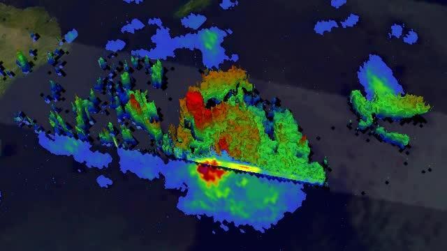
In this TRMM 3-D simulated flyby of System 92B from May 21, some powerful convective storm tops were reaching heights of almost 17 km (about 10.5 miles).
(Photo Credit: Image : NASA/SSAI, Hal Pierce)
By 08:00 UTC/4 a.m. EDT, the Joint Typhoon Warning Center estimated that System 92B had maximum sustained winds between 25 to 30 knots (28.7 to 34.5 mph/46.3 to 55.5 kph). Metsat satellite imagery indicated that the circulation center is located near 17.0 north latitude and 92.1 east longitude in the Bay of Bengal, about 315 nautical miles south of Chittagong, Bangladesh.
System 92B is moving north at 5 knots (5.7 mph/9.2 kph). Computer models vary on the development of the tropical low pressure area, but do expect it to continue drifting to the north and north-northwest.
The Joint Typhoon Warning Center noted that System 92B's potential for the development of a significant tropical cyclone within the next 24 hours remains high.
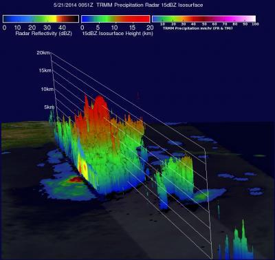
In this TRMM 3-D image of System 92B from May 21, some powerful convective storm tops were reaching heights of almost 17 km (about 10.5 miles).
(Photo Credit: Image : NASA/SSAI, Hal Pierce)
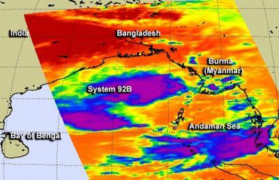
May 22 at 7:11 UTC/3:11 a.m. EDT, NASA's Aqua satellite passed over System 92B and the AIRS instrument saw very cold cloud top temperatures near -63F/-52C (purple) north and west of the center of circulation.
(Photo Credit: Image : NASA JPL/Ed Olsen)
Source: NASA/Goddard Space Flight Center