Tropical Cyclone Peipah passed the island of Palau on April 5 moving through the Northwestern Pacific Ocean as it heads for a landfall in the Philippines. Peipah was formerly known as Tropical Cyclone 05W and was renamed when it reached tropical storm-force. Since then, however, wind shear has weakened the storm to a tropical depression.
On April 5 at 2100 UTC/5 p.m. EDT, Tropical Storm 05W, renamed Peipah (and known locally in the Philippines as Domeng) was located about 262 nautical miles east-southeast of Koror. It was centered near 5.5 north and 137.8 east and moving to the west-northwest at 8 knots/9.2 mph/14.8 kph. Maximum sustained winds were near 35 knots/40 mph/62 kph.
The VIIRS instrument that flies aboard NASA-NOAA's Suomi NPP satellite captured an infrared image of Peipah on April 5 at 16:27 UTC/12:27 p.m. EDT. It showed strong thunderstorms west of the center of circulation as a result of moderate to strong easterly wind shear. That wind shear continued over the next two days as two other satellites saw the same effect.
By April 7 at 0900 UTC/5 a.m. EDT, Peipah had weakened to a tropical depression with maximum sustained winds near 25 knots/28.7 mph/46.3 kph. It was located near 6.4 north and 132.1 east, about 819 nautical miles southeast of Manila, Philippines. Peipah was moving to the west-southwest at 15 knots/17.2 mph/27.8 kph and is expected to turn to the west-northwest making landfall in northeastern Mindanao before moving through the central or Visayas region. Mindanao is the second largest and southernmost major island in the Philippines.
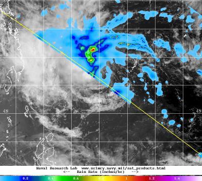
This composite TRMM and MTSAT-2 satellite image taken on April 7 shows the bulk of Peipah's clouds and showers pushed west-northwest of the storm's center. Heaviest rainfall was occurring at a rate of 1 inch/25 mm per hour (red) northwest of the center.
(Photo Credit: Image : NRL/NASA/JAXA)
Satellite imagery on April 7 continued to show that the main convection and thunderstorms were still being pushed to the west-northwest of the center as a result of vertical wind shear. An image Peipah showing clouds and rainfall was created by the Naval Research Laboratory that combines rainfall rate data from NASA's TRMM satellite with cloud imagery from Japan's MTSAT-2 satellite. The images, taken at 0544 UTC/1:44 a.m. EDT and 5:23 UTC/1:23 a.m. EDT, respectively show the clouds and showers pushed to the west-northwest of the center. The TRMM data showed that the heaviest rainfall was occurring at a rate of 1 inch/25 mm per hour northwest of the center.
The Philippine Atmospheric, Geophysical and Astronomical Services Administration issued a Tropical Cyclone Warning for Shipping on April 7.
Peipah continues to move west-northwest toward the Philippines and the Joint Typhoon Warning Center forecasters do not expect the storm to intensify much before landfall.
Source: NASA/Goddard Space Flight Center