NOAA's GOES-East satellite captured imagery of the Atlantic Ocean's Tropical Depression 2 is it degenerated into a tropical wave on July 23.
At 1445 UTC (10:45 a.m. EDT), NOAA's GOES-East satellite captured an image of what was once Tropical Depression 2 (TD2), about 400 miles east of the Lesser Antilles. The GOES-East visible satellite imagery indicated that the depression weakened since July 22. TD2 appeared as just a weak swirl of clouds with no strong thunderstorms or deep convection. The GOES image was created by NASA/NOAA's GOES Project at NASA's Goddard Space Flight Center in Greenbelt, Maryland.
In addition, the NHC noted that low-level cloud motions showed no evidence of a closed surface circulation and declared TD2 a remnant low pressure area.
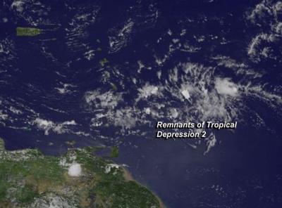
TD2 appeared as just a weak swirl of clouds with no strong thunderstorms or deep convection.
(Photo Credit: Image : NASA/NOAA GOES Project)
At 11 a.m. EDT (1500 UTC), the National Hurricane Center (NHC) issued their final advisory on TD2, and cited that it had degenerated into a tropical wave. Despite that, the remnants of the depression are expected to move through the Lesser Antilles this evening (July 23) with some areas of gusty winds and showers, according to the NHC.
The last NHC advisory placed the center of the degenerated depression's center near 14.0 north latitude and 56.0 west longitude, about 365 miles (590 km) east-southeast of the Lesser Antilles. It was moving quickly to the west at 25 mph (41 kph) and had maximum sustained winds near 35 mph (55 kph) what were quickly waning. TD2's minimum central pressure was near 1012 millibars.
Source: NASA/Goddard Space Flight Center