Boulder, Colo., USA - Can spaceborne radar help predict sinkholes? What do ancient ambers reveal about paleochemotaxonomy? How does serpentinization affect sub-seafloor environments? Can OAE2 help us understand current global warming? Did trilobites venture into upper intertidal zones? When did vast landmasses first emerge above sea level? What does the 27 March 2013 6.2 M earthquake reveal about central Taiwan? How do you reconstruct snapshots of a catastrophic radial current? What is a cryptic coral-crinoid hanging garden?
These questions (and answers) are highlighted below. Geology articles published ahead of print can be accessed online at http://geology.gsapubs.org/content/early/recent. All abstracts are open-access at http://geology.gsapubs.org/; representatives of the media may obtain complimentary Geology articles by contacting Kea Giles at the address above.
Please discuss articles of interest with the authors before publishing stories on their work, and please make reference to Geology in articles published. Contact Kea Giles for additional information or assistance.
Non-media requests for articles may be directed to GSA Sales and Service, gsaservice@geosociety.org.
Bayou Corne, Louisiana, sinkhole: Precursory deformation measured by radar interferometryCathleen E. Jones (cathleen.e.jones@jpl.nasa.gov) and Ronald G. Blom, Jet Propulsion Laboratory, California Institute of Technology, MS 300-319, 4800 Oak Grove Drive, Pasadena, California 91109, USA. Posted online ahead of print on 13 Dec. 2013; http://dx.doi.org/10.1130/G34972.1.
The Bayou Corne sinkhole in Louisiana formed over night on 3 August 2012, startling local residents who had been reporting small seismic events and bubbling in the bayous over the prior few weeks. The sinkhole developed above the collapsing sidewall of Texas Brine's Oxy #3 cavern in the Napoleonville Salt Dome, with an initial size of ~1 hectare. As the sinkhole continues to enlarge, engulfing more of the local land and trees, the community of Bayou Corne is now largely abandoned. The JPL/NASA UAVSAR radar system has been collecting data over southeastern Louisiana since 2009 and analysis of the data acquired over Bayou Corne reveal surface deformation of up to 26 cm that occurred at least one month prior to sinkhole formation. Significantly, no deformation is seen prior to June 2011, in accord with residents' observations of unusual activity starting around June 2012. These observations, and other radar interferometric observations of sinkholes, demonstrate that radar remote sensing data collected operationally for hazards monitoring could identify some at-risk areas prior to surface collapse. Airborne and spaceborne radar can rapidly survey large areas, measuring motion across the entire area, complementing surface survey methods that provide precise information about movement at a single location.
Exceptional preservation of angiosperm markers in Miocene and Eocene ambersSuryendu Dutta et al., Dept. of Earth Sciences, Indian Institute of Technology Bombay, Powai, Mumbai 400076, India, s.dutta@iitb.ac.in. Posted online ahead of print on 13 Dec. 2013; http://dx.doi.org/10.1130/G34975.1.
The traditional organic geochemical view suggests that polar triterpenoids are degraded easily during fossilization of organic matter. For the first time, a team from the Indian Institute of Technology Bombay demonstrates that oxygenated dammarane-type (a tetracyclic triterpene found in sapogenins like those of ginseng) compounds are preserved in geological samples of Miocene and Eocene ambers. The presence of hydroxydammarenone in Miocene amber clearly depicts that natural biotriterpenoid markers can be preserved in the geosphere for tens of millions of years. This result demonstrates that the dammarane-type oxygenated compounds, which are extensively used in archaeological studies, can be utilized as valuable markers for paleobotanical studies.
Magnetite in seafloor serpentinite -- Some like it hotFrieder Klein et al., Woods Hole Oceanographic Institution, Woods Hole, Massachusetts 02543, USA, fklein@whoi.edu. Posted online ahead of print on 13 Dec. 2013; http://dx.doi.org/10.1130/G35068.1.
Rocks of Earth's mantle unroofed by tectonic forces interact with seawater along plate boundaries, such as mid-ocean ridges, continental margins, and subduction zones. This process, referred to as serpentinization, generates substantial amounts of hydrogen, which supports a deep biosphere in sub-seafloor environments with chemical energy. While hydrogen generation is commonly attributed to the precipitation of magnetite (an iron oxide formed during serpentinization), we find that low-temperature serpentinization produces Ni-Fe alloy but hardly any magnetite. Despite the small amounts of magnetite, abundant hydrogen is generated through ferric iron hosted in serpentine (the dominant mineral group formed during serpentinization), lending support to the idea that low- to moderate-temperature serpentinization can generate abundant hydrogen within the temperature limits of life.
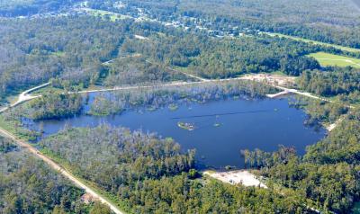
The Bayou Corne Sinkhole formed on Aug. 3, 2012, following sidewall collapse of the Texas Brine Oxy Geismar #3 storage cavity within the Napoleonville Salt Dome in southern Louisiana.
(Photo Credit: Photo date: Aug. 12, 2012; : On Wings of Care. Geology article by C. Jones et al.)
A perturbed hydrological cycle during Oceanic Anoxic Event 2Niels A.G.M. van Helmond et al., Department of Earth Sciences, Faculty of Geosciences, Utrecht University, Budapestlaan 4, 3584 CD Utrecht, Netherlands, n.vanhelmond@uu.nl. Posted online ahead of print on 13 Dec. 2013; http://dx.doi.org/10.1130/G34929.1.
Changes in rainfall accompanied and perhaps partly caused the development of oxygen-poor oceans (OAE2), about 94 million years ago. Since the seventies it is known that at that time, the age of the dinosaurs, ocean waters in many regions became poor in oxygen, which all animals require. OAE2 is, hence, often regarded as an analogue of today, as oxygen concentrations are currently decreasing in many coastal waters due to human impact. This new paper shows evidence for large changes in the water cycle during OAE2, based on the chemistry and microfossils preserved in sediments deposited in a shallow sea, the current New Jersey coastal plain. When widespread ocean-anoxia developed, marine algae show an increase in fresh water from rivers. Moreover, during a brief cooling, when oceans became slightly richer in oxygen, freshwater supply decreased and dust input increased. This indicates that climate, not only temperature but also precipitation, was strongly coupled to the availability of oxygen in the ocean. Potentially, the additional supply of freshwater to coastal waters regionally inhibited the mixing of oxygen-rich surface waters with deeper waters, causing a lack of oxygen. Analogously, modern global warming and associated intensification of seasonal rainfall might also result in near-shore oxygen depletion.
Trilobites in early Cambrian tidal flats and the landward expansion of the Cambrian explosionM. Gabriela Mángano et al., Department of Geological Sciences, University of Saskatchewan, 114 Science Place, Saskatoon, Saskatchewan S7N 5E2, Canada, . Posted online ahead of print on 13 Dec. 2013; http://dx.doi.org/10.1130/G34980.1.
The Cambrian witnessed the rapid development of almost all modern groups of animals, including the rise of skeletal faunas, a major evolutionary event known as the Cambrian explosion. Trilobites were among the most important elements of the so-called Cambrian Evolutionary Fauna. Until now, it has been considered that trilobites have been essentially restricted to fully marine subtidal settings. New research by an international team led by scientists from the University of Saskatchewan, Canada, is now challenging this view. Their study is based on the discovery of trace fossils produced by trilobites in alternating sands and silts formed under intertidal conditions in a Cambrian tidal flat preserved in what is now the Appalachians. The biogenic structures are present in layers that show clear evidence of subaerial exposure. This study provides convincing evidence that trilobites were able to foray into the upper intertidal zone during the rising tides. Intertidal ecosystems may have provided food resources and acted as refuges for trilobites and other migrant arthropods. This study adds a new step in our understanding of the ecologic implications of Cambrian explosion and the early colonization of the land.
Decoupled Hf-Nd isotopes in Neoarchean seawater reveal weathering of emerged continentsSebastian Viehmann et al., Steinmann Institut, Rheinische Friedrich-Wilhelms-Universität Bonn, 53115 Bonn, Germany; Current address: Earth and Space Science Program, Jacobs University Bremen, 28759 Bremen, Germany, s.viehmann@jacobs-university.de. Posted online ahead of print on 13 Dec. 2013; http://dx.doi.org/10.1130/G35014.1.
When in Earth's history did vast landmasses first emerge above sea level? This fundamental geological question is still subject to controversy. Numerical simulations, for example, suggested that 2,500 million years ago only 3% of Earth's surface area was dry. A new geochemical approach to address this issue utilizes the distribution of rare trace elements (zirconium, hafnium, and rare earth elements) and the isotopic composition of hafnium (Hf) and neodymium (Nd) in ancient seawater. Unusually pure iron-rich chemical sediments (banded iron-formation, BIF) from Temagami, Ontario, Canada, are an archive of 2,700 million years-old seawater, which allows us to extend the Hf isotope record of seawater back in time to the Early Earth's ocean. The Temagami BIF shows that 2,700 million years ago, seawater was anomalously enriched in the radiogenic Hf-176 isotope, whereas its Nd isotopic composition was normal. This reveals that the same decoupling of Hf and Nd isotopes that is observed in the modern ocean, did already persist 2,700 million years ago. This required the existence of landmasses that were subjected to terrestrial erosion and weathering, indicating that already 2,700 million years ago, large areas of dry land were emerged above sea level and exposed to wind and rain.
Basin inversion in central Taiwan and its importance for seismic hazardGiovanni Camanni et al., Institute of Earth Sciences Jaume Almera, ICTJA-CSIC, Lluis Sole i Sabaris s/n, 08028 Barcelona, Spain, gcamanni@ictja.csic.es; camannini@gmail.com. Posted online ahead of print on 13 Dec. 2013; http://dx.doi.org/10.1130/G35102.1.
On 27 March 2013, a 6.2 ML earthquake occurred at ~20 km depth in eastern Nantou, central Taiwan, below the ~10-km-deep detachment fault, which is thought to be the deepest level of deformation in this part of the mountain belt. In this paper, Giovanni Camanni and colleagues combine geological and earthquake seismicity data to determine a new model for the structure of central Taiwan to be used when assessing seismic risk in this area. They found that a structural model in which preexisting, rift-related extensional faults are reactivated and basins that were located on the Eurasian margin are inverted better fits the available data than does the wedge-shaped, detachment model.
Temporal and spatial evolution of a waxing then waning catastrophic density current revealed by chemical mappingRebecca Williams et al., Dept. of Geology, University of Leicester, University Road, Leicester LE1 7RH, UK; Current address: Dept. of Geography, Environment and Earth Sciences, University of Hull, Hull HU6 7RX, UK; rebecca.williams@hull.ac.uk; dr.williams.r@gmail.com. Posted online ahead of print on 13 Dec. 2013; http://dx.doi.org/10.1130/G34830.1.
Searing-hot, ground-hugging pyroclastic density currents of ash and gases are the most deadly volcanic phenomena and are difficult to observe to understand their flow behavior. Rebecca Williams and colleagues have developed a novel technique to reconstruct snapshots of a catastrophic radial current as it evolved through time, by using chemical variations within the deposit of a single current, combined with detailed fieldwork. For the first time with any type of density current, they have revealed where this current flowed at timescales of several minutes, demonstrating how such currents gradually envelop the landscape, shifting their flow-paths and responding to large topographic barriers, and eventually overtopping all hills to a climax during which the entire landscape was inundated. Then, as the eruption waned, the current's extent retreated sourceward until only a small area of land was covered. The current in this study left behind a remarkable deposit, the Green Tuff ignimbrite (Pantelleria, Italy), that was so hot that it welded upon deposition, and covered an entire island in green volcanic glass, including steep slopes of up to 80 degrees. This work is important for helping understand volcanic hazards and to the wider density current community, such as those working on marine turbidity currents.
Cryptic coral-crinoid "hanging gardens" from the Middle Devonian of southern MoroccoMichal Jakubowicz et al., Faculty of Geographical and Geological Sciences, Adam Mickiewicz University, ul. Dzięgielowa 27, 61-680 Poznań, Poland; mjakub@amu.edu.pl; mjakubowicz87@gmail.com. Posted online ahead of print on 13 Dec. 2013; http://dx.doi.org/10.1130/G35217.1.
Despite being invaluable tools of paleoecological reconstructions of ancient marine benthic faunas, fossil cryptic (i.e., cavity-dwelling) communities remain poorly known, and their fossil record is very fragmentary. In the present contribution we report a discovery of an unusual and exceptionally well-preserved cryptic community of corals, crinoids, sponges and microbes developed in a submarine cavity of Devonian age in the Hamar Laghdad area (Morocco). The biota encrusted the cavity roof and grew predominantly in an upside-down position, forming spectacular "hanging gardens." The study provides new insights into the paleoecology and dynamics of Paleozoic cryptic assemblages. The investigated community differs strikingly from its both Paleozoic and modern analogues; it constitutes one of a very few known examples of fossil cryptic assemblages developed in relatively deep-water settings, and the first report of a cryptic paleoecosystem dominated by rugose corals. The results support the view that during the Middle Paleozoic there was no distinct polarization between open-surface and cryptic faunas in deep-water environments, but keen competition for space already existed in Devonian cryptic assemblages. The regional species pool seems to have been the main determinant of the ecological succession and structure of this cryptic community.
Source: Geological Society of America