Ita was still over 400 miles from Cairns, Australia at 0900 UTC/5 a.m. EDT. It was centered near 11.5 south and 150.2 east and moving to the west at 9 knots/10.3 mph/16.6 kph. The Joint Typhoon Warning Center (JTWC) noted that Ita is generating 25-foot/7.6 -meter high waves in the Coral Sea.
On April 9, animated multispectral satellite imagery showed Ita has tightly curved bands of thunderstorms wrapping into a consolidating low level circulation center. TRMM microwave imagery revealed a well-formed eye around that consolidating center.
The Joint Typhoon Warning Center (JTWC) is forecasting Ita to strengthen over the next two days with maximum sustained winds peaking near 105 knots before weakening from interaction with the land. Ita is expected to move southwest through the Coral Sea and reach the eastern Cape York Peninsula, Queensland by Friday, April 11. The Australian Bureau of Meteorology (ABM) noted that Ita is expected to cross the far north Queensland coast between Lockhart River and Cape Flattery late Friday.
ABM has posted a Cyclone Watch for coastal areas from Cape Grenville to Cairns, extending up to 124 miles/200 kilometers inland to areas including Kalinga, Laura, and Palmerville. For updates, visit the ABM website: http://www.bom.gov.au/cyclone/index.shtml.
From April 11 through the 14, JTWC expects an approaching shortwave trough (elongated area of low pressure) to begin pushing Ita away from the coast. Current JWTC forecasts take Ita's center near Cairns and slowly turn Ita in a southeasterly direction causing the storm parallel the Queensland coast to Brisbane.
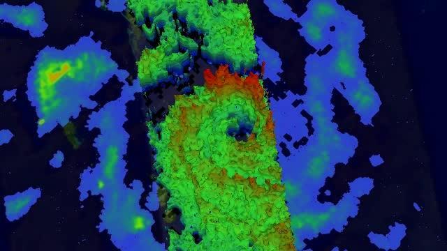
This simulated 3-D flyby animation using TRMM precipitation radar data on April 9 shows rain falling at a rate of over 99 mm/3.9 inches per hour (red) within Ita's feeder bands over the coast of southeastern Papua New Guinea.
(Photo Credit: NASA/SSAI, Hal Pierce)
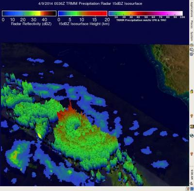
On April 9, the TRMM satellite saw rain falling at a rate of over 99 mm/3.9 inches per hour within Ita's feeder bands over the coast of southeastern Papua New Guinea.
(Photo Credit: NASA/SSAI, Hal Pierce)
Source: NASA/Goddard Space Flight Center