NASA's Tropical Rainfall Measuring Mission or TRMM satellite captured an image of Haiyan just as it was crossing the island of Leyte in the central Philippines. Data was taken at 00:19 UTC (8:19 a.m. local) November 8, 2013 and showed the horizontal distribution of rain intensity within the Haiyan. Rain rates in the center of the swath were generated from the TRMM Precipitation Radar (PR), and those in the outer swath were from the TRMM Microwave Imager (TMI). The data was put together at NASA's Goddard Space Flight Center in Greenbelt, Md. where rain rates were overlaid on infrared (IR) data from the TRMM Visible Infrared Scanner (VIRS). It showed that Haiyan still had a well-defined eye surrounded by a symmetric area of moderate rain with several rainbands wrapping in from the south. The symmetric rain area around the eye is a testament to the storm's intensity--the stronger the storm, the more the features are smeared uniformly around the center. At the time of the image, Haiyan's sustained winds were estimated to have dropped slightly to 160 knots/~185 mph from crossing Leyte.
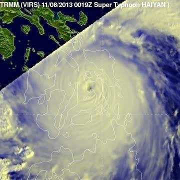
NASA's TRMM satellite data on Nov. 8 at 00:19 UTC showed Haiyan had a well-defined eye surrounded by a symmetric area of moderate rain (green ring with a blue center) with several rainbands wrapping in from the south (green arcs) while crossing the island of Leyte in the central Philippines.
(Photo Credit: NASA/SSAI, Hal Pierce)
TRMM passed over Haiyan about 10 hours later on Nov. 8 at 10:08 UTC/5:08 a.m. EDT/6:08 p.m. Philippines local time. Haiyan was passing south of Mindoro as it was beginning to exit the Philippines. The center was less organized after having passed over the larger Philippines island of Panay, although a large area of heavy rain (shown in red) is now located just south of the center. At the time of this image, Haiyan's intensity was estimated to be 145 knots/~167 mph, still equivalent to a Category 5 hurricane. TRMM is a joint mission between NASA and the Japanese space agency JAXA.
On Nov. 8 at 1500 UTC/11 a.m. EDT/12 a.m. Nov. 9 Philippines local time, Haiyan's maximum sustained winds had dropped to 135 knots/155.4 mph/250 kph. It slowed a bit, moving to the west at 20 knots/23.0 mph/37.0 kph. Although Haiyan was centered near 11.8 north and 120.6 east, about 170 miles south of Manila, its extent covered most of the Philippines.
So far, four fatalities have been reported as a result of the storm, but these are preliminary as communication to many areas was knocked out. Haiyan is expected to continue moving in a general westward direction over the next 1 to 2 days before likely striking central Vietnam.
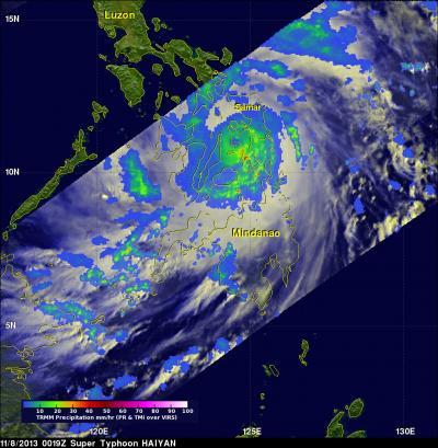
NASA's TRMM satellite data on Nov. 8 at 00:19 UTC showed Haiyan had a well-defined eye surrounded by a symmetric area of moderate rain (green ring with a blue center) with several rainbands wrapping in from the south (green arcs) while crossing the island of Leyte in the central Philippines.
(Photo Credit: NASA/SSAI, Hal Pierce)
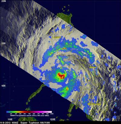
TRMM saw Haiyan's center was less organized after having passed over the larger Philippines island of Panay, although a large area of heavy rain (shown in ed) is now located just south of the center. Haiyan was estimated to be 145 knots (~167 mph), still equivalent to a Category 5 hurricane.
(Photo Credit: NASA/SSAI, Hal Pierce)
Source: NASA/Goddard Space Flight Center