Computer models indicate that Ex-Tropical Cyclone Gillian will re-intensify to at least 35 knots/40 mph/62 kph over the next 24 to 36 hours. Maximum sustained surface winds are estimated at 25 to 30 knots/ 28.7 to 34.5 mph/46.3 to 55.5 kph. Minimum sea level pressure is estimated to be near 1001 millibars.
The Australian Bureau of Meteorology has posted a warning and a watch for Ex-Tropical Cyclone Gillian. A Cyclone Warning continues for coastal and island communities from Elcho Island to Numbulwar, including Alyangula and Nhulunbuy. A Cyclone Watch continues for coastal areas from Croker Island to Elcho Island.
The warning stated that Gillian is expected to approach the coast near Nhulunbuy early Sunday (March 16) morning then continue heading west near the northern coast of the Top End.
Residents between Numbulwar and Nhulunbuy, including Alyangula can expect gusty winds today, March 14, and those conditions will spread west on March 16. In addition to the winds, heavy rainfall, higher than normal tides and large waves will accompany Gillian as it moves west.
The Australian Bureau of Meteorology expects Gillian's remnants to meander in the Gulf of Carpentaria for the next day before setting course to the northwest and moving past Nhulumbuy and Elcho Island, Northern Territory on March 16 and 17. For updated watches and warnings, visit: http://www.bom.gov.au/cyclone.
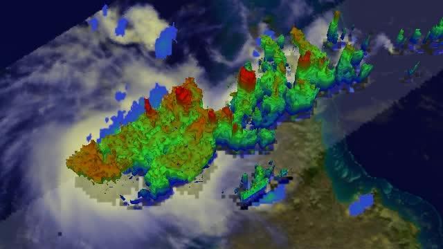
On March 14, 2014, at 1 a.m. EDT this simulated 3-D flyby of the TRMM satellite showed rain falling at the rate of over 116 mm/4.5 inches per hour (red), and some storms were higher than 16.75 km/10.4 miles.
(Photo Credit: NASA/SSAI, Hal Pierce)
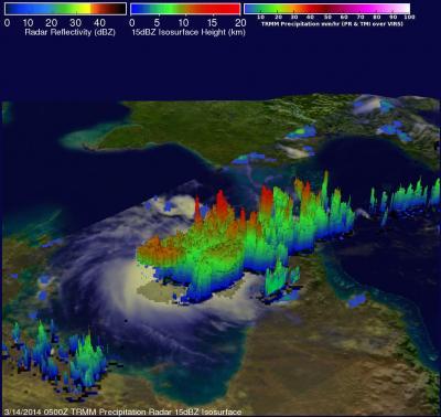
On March 14, 2014, at 1 a.m. EDT the TRMM satellite found rain falling at the rate of over 116 mm/4.5 inches per hour (red), and some storms were higher than 16.75 km/10.4 miles.
(Photo Credit: NASA/SSAI, Hal Pierce)
Source: NASA/Goddard Space Flight Center