TRMM satellite data from Sept. 16 at 0227 UTC (Sept. 15 at 10:27 p.m. EDT) were used to create a 3-D image of Ingrid's rainfall. That 3-D image of Tropical Storm Ingrid's rainfall showed heaviest rainfall appeared over the Gulf of Mexico, where rain was falling at a rate of 2 inches/50 mm per hour. Moderate rainfall stretched from the Gulf northwest and inland over eastern Mexico.
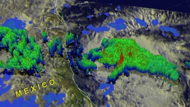
This 3-D flyby of Tropical Storm Ingrid's rainfall was created from TRMM satellite data for Sept. 16. Heaviest rainfall appears in red towers over the Gulf of Mexico, while moderate rainfall stretched from there inland over eastern Mexico.
(Photo Credit: SSAI/NASA, Hal Pierce)
The National Hurricane Center issued the final advisory on the remnants of Ingrid on Tuesday, Sept. 17 at 5 a.m. EDT. At that time Ingrid's remnants were located near latitude 23.7 north and longitude 99.9 west about 50 miles/75 km west of Ciudad Victoria, Mexico. The remnant low pressure area and associated showers and thunderstorms were moving westward at 5 mph/ 7 kph. Ingrid's maximum sustained winds have decreased to near 25 mph/35 kph.
The National Hurricane Center noted that the remnants of Ingrid are expected to produce 10 to 15 inches of rain over a large part of eastern Mexico with isolated amounts of 25 inches possible, especially in areas of mountainous terrain. That rainfall from Ingrid's remnants is expected to cause flooding and mud-slides over eastern Mexico for the next few days.
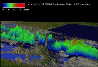
This 3-D image of Tropical Storm Ingrid's rainfall was created from TRMM satellite data for Sept. 16. Heaviest rainfall appears in red towers over the Gulf of Mexico, while moderate rainfall stretched from there inland over eastern Mexico.
(Photo Credit: SSAI/NASA, Hal Pierce)
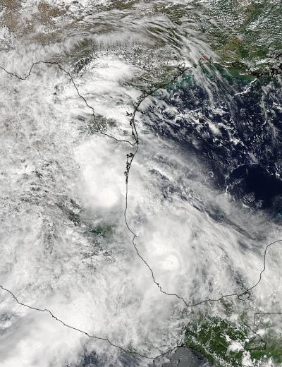
NASA's Aqua satellite captured this visible image of Tropical Storm Ingrid over Mexico on Sept. 16 at 1945 UTC/3:45 p.m. EDT as it continued to soak northeaster Mexico. The northern extent of Ingrid's clouds stretch over southern Texas.
(Photo Credit: NASA Goddard MODIS Rapid Response Team)
Source: NASA/Goddard Space Flight Center