NASA's TRMM and Aqua satellites have been providing views of the outside and inside of Hurricane Cristobal as it heads for Bermuda. The National Hurricane Center posted a Tropical Storm Watch for Bermuda as Cristobal heads in that direction.
Strong winds and flooding associated with Tropical Storm Cristobal caused deaths in the Dominican Republic, Haiti, and Jamaica. The Tropical Rainfall Measuring Mission or TRMM satellite captured rainfall data from Cristobal on August 24, 2014 at 1150Z (7:50 a.m. EDT). Light to moderate rainfall was occurring throughout much of the depression, with the exception of an area of heavy rainfall in the southeastern Bahamas where rain rates exceeded 2 inches/50 mm per hour. At that time Cristobal was a tropical depression, and shortly after TRMM passed overhead, Tropical Depression Four was upgraded to tropical storm status.
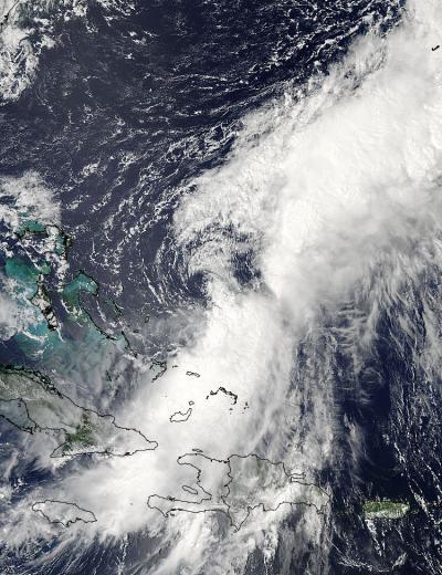
On Aug. 25 at 18:10 UTC NASA's Aqua satellite captured this visible image of Tropical Storm Cristobal over the Bahamas as strong wind shear pushed its thunderstorms northeast of the center.
(Photo Credit: Image : NASA Goddard MODIS Rapid Response Team)
The next day, on August 25, 2014 at 1230 UTC (8:30 a.m. EDT). Cristobal encountered strong wind shear and the center appeared rain-free on TRMM satellite imagery. TRMM found that most of the intense rain was falling at a rate of over 159.3 mm (about 6.3 inches) per hour in a line of storms that was located well to the northeast of Cristobal's center.
On Aug. 25 at 18:10 UTC (2:10 p.m. EDT) the Moderate Resolution Imaging Spectroradiometer or MODIS instrument that flies aboard NASA's Aqua satellite captured a visible image of Tropical Storm Cristobal over the Bahamas. In the image, it is clear that strong wind shear had pushed thunderstorms northeast of Cristobal's center. Despite the wind shear, Cristobal maintained hurricane force.
On August 26 at 11 a.m. EDT as Cristobal continued moving north, NOAA buoy 41047 which is located just north of the storm's center at time, reported a sustained wind of 45 mph (72 kph) and a wind gust of 51 mph (83 kph).
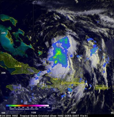
The TRMM satellite captured Cristobal's rainfall on Aug. 24 at 7:50 a.m. EDT. Red areas indicate heavy rainfall.
(Photo Credit: Image : NASA/SSAI, Hal Pierce)
At 11 a.m. EDT on August 26, Cristobal's maximum sustained winds were near 75 mph (120 kph) and the National Hurricane Center expects some strengthening. The center was located near latitude 27.2 north and longitude 71.7 west. That's about 545 miles (875 km) southwest of Bermuda. Cristobal is moving toward the north near 12 mph (19 kph) and a northward to north-northeastward is expected to continue through tonight, followed by turn to the northeast on Wednesday, August 27.
On the forecast track, the National Hurricane Center expects that the center of Cristobal will pass northwest of Bermuda on Wednesday.
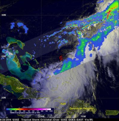
On Aug. 25 TRMM saw that Cristobal's center was rain-free because of wind shear. The most intense rain, falling at over 159.3 mm/6.3 inches per hour in a line of storms that was located well to the northeast of Cristobal's center.
(Photo Credit: Image : NASA/SSAI, Hal Pierce)
Source: NASA/Goddard Space Flight Center