Tropical Storm Ana was being battered by wind shear when NASA's Terra satellite passed overhead and saw the bulk of showers and thunderstorms pushed north and east of the center.
NASA's Terra satellite flew over Tropical Storm Ana as it was moving past Hawaii on Oct. 21 at 21:30 UTC (5:30 p.m. EDT) and the Moderate Resolution Imaging Spectroradiometer (MODIS) instrument took a visible picture of the storm. The MODIS image showed that the strong southwesterly wind shear that was affecting the storm on Oct. 20 continued through Oct. 21 as the bulk of clouds and showers were north and east of the center. The center appeared as an open area with a sprinkling of fragmented clouds around it.
At 8 a.m. EDT (2 a.m. HST) on Oct. 22, NOAA's Central Pacific Hurricane Center noted that thunderstorms with tops to 53,000 feet were northeast of the center, with additional thunderstorms embedded within the layered clouds that extend about 250 miles to the northwest through east of the center.
At 11 a.m. EDT (5 a.m. HST/1500 UTC) the center of tropical storm Ana was located near latitude 22.8 north and longitude 167.4 west. That puts Ana's center about 105 miles (165 km) southwest of French Frigate Shoals and about 515 miles (825 km) west of Lihue, Hawaii. Maximum sustained winds were near 40 mph (65 kph) and CPHC forecasters expect some strengthening through early Friday, Oct. 24.
Ana is moving toward the northwest near 8 mph (13 kph) and this motion is expected to gradually become northerly through early Friday. The estimated minimum central pressure is 1005 millibars.
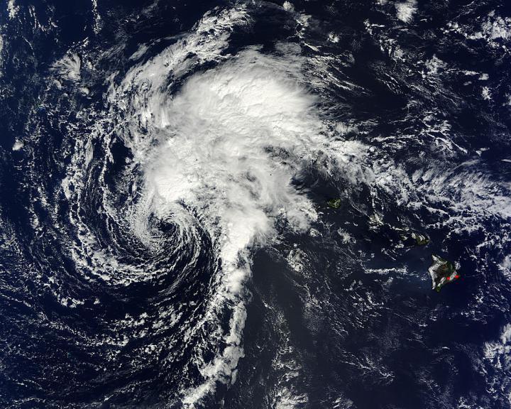
NASA's Terra satellite captured this image of Tropical Storm Ana moving past Hawaii on Oct. 21 at 21:30 UTC (5:30 p.m. EDT).
(Photo Credit: NASA's Goddard MODIS Rapid Response Team)
A tropical storm warning was in effect on Oct. 22 for portions of the Papahanaumokuakea Marine National Monument, from Nihoa to Lisianski.
CPHC noted that tropical storm conditions are expected over French Frigate Shoals, Necker Island and Gardner Pinnacles, and nearby waters, today and tonight, Oct. 22. Large swells produced by Ana will build across the northwest Hawaiian Islands today and tonight. Surf produced by these swells will be dangerous along the southern and southeastern facing reefs of the northwest Hawaiian Islands. In addition, rainfall amounts of 4 to 8 inches are possible over the northwest Hawaiian Islands near the center of Ana.
Ana is moving northwest and is expected strengthen as it moves through the western part of the Papahanaumokuakea Marine National Monument.
Ana dropped almost a foot of rainfall on Oahu and the big island of Hawaii, with totals as much as 3 to 6 inches on the other Hawaiian Islands. CPHC rainfall totals appear below.
Hurricane Ana Rainfall Totals from NOAA's Central Pacific Hurricane Center
The following are total rainfall amounts reported beginning on Friday afternoon, Oct. 17 to the National Weather Service's Central Pacific Hurricane Center. Rainfall continues across portions of Kauai and Oahu. These preliminary totals were calculated using provisional reports from automated rain gages that have not been quality controlled.
LOCATIONAMOUNTKAUAIMOUNT WAIALEALE RAINGAGE 6.04KILOHANA RG – USGS 4.88WAILUA DITCH – USGS 3.83OAHUMANOA LYON ARBO 11.05POAMOHO RG 1 – USGS 7.47MOANALUA - USGS – USGS 6.89MOLOKAIPUU ALII 3.22KAUNAKAKAI MAUKA 1.08KAHOOLAWEKAHOOLAWE 3.25MAUIKULA FOREST 3.54PUU KUKUI - USGS 3.08KEPUNI - USGS 2.45HAWAIIKEAUMO 11.67KULANI NWR 8.61KAPAPALA RCH 7.66HILO AIRPORT 5.34MAUNA LOA SLOPE OBS 5.32
Source: NASA/Goddard Space Flight Center