Powerful thunderstorms in newborn Tropical Storm Marie were seen stretching toward the top of the troposphere in infrared imagery from NASA's Aqua satellite.
NASA's Aqua satellite passed over Tropical Storm Marie on Aug. 21 at 20:05 UTC when it was still classified as a low pressure area. The Atmospheric Infrared Sounder or AIRS instrument aboard Aqua read cloud top temperatures in the storm, and showed cloud tops as cold as -63F/-52C around the storm's center and in bands of thunderstorms east and south of the center. AIRS data showed that Marie is located in very warm waters with surface temperatures near 30 Celsius (85 Fahrenheit), which will assist the storm in development and intensification. Sea surface temperatures of at least 26.6C (80F) are needed to maintain a tropical cyclone, while warmer sea surface temperatures can help in evaporation and thunderstorm development.
Marie came together off of Mexico's southwestern coast at 11 p.m. EDT on August 21 consolidating into Tropical Depression 13-E. By 5 a.m. EDT on August 22, the depression strengthened into Tropical Storm Marie.
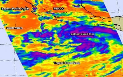
NASA's Aqua satellite captured infrared data on Aug. 21 at 20:05 UTC of Tropical Storm Marie's cloud top temperatures as it came together off of Mexico's southwestern coast.
(Photo Credit: Image : NASA JPL, Ed Olsen)
Marie's maximum sustained winds increased to near 45 mph (75 kph) and the National Hurricane Center (NHC) expects rapid intensification. In fact, forecasters expect Marie to become a hurricane late in the day on August 22 and reach major hurricane status (Category 3 or greater on the Saffir-Simpson Wind Scale) by Monday, August 25.
At 5 a.m. EDT, August 22, the center of Tropical Storm Marie was located near latitude 12.8 north and longitude 101.0 west. Marie is moving toward the west-northwest near 16 mph (26 kph) and is expected to slow as it intensifies. The estimated minimum central pressure is 1004 millibars.
The NHC noted that satellite microwave data showed that Marie has a well-defined low-level ring, which can often be a precursor to rapid intensification if environmental conditions are favorable.
Source: NASA/Goddard Space Flight Center