As Typhoon Melor weakened to a tropical storm as it moved through the islands of the Philippines, NASA's Aqua satellite captured an image of the storm on Dec. 16.
NASA's Aqua satellite passed over Melor, known locally as Nona, on Dec. 16 at 0500 UTC (12 a.m. EST). The Moderate Resolution Imaging Spectroradiometer aboard Aqua captured a visible image of the weaker storm and the center of circulation was difficult to pinpoint because of strong wind shear affecting the system.
The Joint Typhoon Warning Center noted that strong vertical winds shear between 30 to 40 knots continues to decouple the low and upper level features. A tropical cyclone is like a stack of rotating tires. If one of the tires is pushed out of the stack, the rotation becomes wobbly, weaker and slower. That's what vertical wind shear does to different layers of a tropical cyclone.
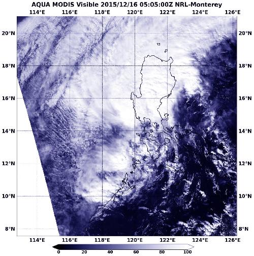 The MODIS instrument on NASA's Aqua satellite captured this image of Tropical Storm Melor on Dec. 16 at 0500 UTC (12 a.m. EST) moving over Luzon, Philippines. Credit: Credits: NASA Goddard MODIS Rapid Response
At 1500 UTC (10 a.m. EST), Tropical storm Melor was centered near 16.0 degrees north latitude and 119.4 degrees east longitude, about 125 nautical miles (143.8 miles/231.5 km) northwest of Manila, Philippines. Melor was moving to the north at 7 knots (8 mph/12.9 kph) and maximum sustained winds were down to 50 knots (57.5 mph/92.6 kph).
Philippine warnings were still in effect as Melor continued to move through Luzon. Public storm warning signal #2 was in effect in the following Luzon provinces: Bataan, Southern Zambales, Cavite, Batangas and Lubang Island. Public storm warning signal #1 was in effect in the following provinces: Luzon: Metro Manila, rest of Zambales, Pampanga, Bulacan, Tarlac, Rizal, Laguna, Northern Occidental Mindoro and Northern Oriental Mindoro.
The Joint Typhoon Warning Center noted that Melor's center is over the South China Sea, and will move north parallel to the Luzon coast before turning to the southwest. Melor is expected to then weaken quickly over the South China Sea as it encounters cooler waters, dry air and continues to deal with wind shear.
source: NASA/Goddard Space Flight Center