The fifth tropical depression of the northwestern Pacific Ocean tropical cyclone season formed far from land as NASA's Aqua satellite passed overhead and captured a visible image of the storm on April 4.
NASA's Aqua satellite passed over newborn Tropical Depression 05W on April 3 at 03:10 UTC/April 2 at 11:10 p.m. EDT. The Moderate Resolution Imaging Spectroradiometer or MODIS instrument captured a visible picture of the storm, revealing good circulation and strong convection and thunderstorms around the center of circulation.
The Joint Typhoon Warning Center or JTWC noted that animated multispectral satellite imagery today, April 3, showed that the low-level circulation center has been consolidating and that there is fragmented convective banding of thunderstorms around the center.
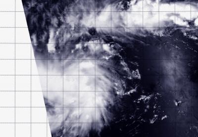
NASA's Aqua satellite passed over newborn Tropical Depression 05W on April 3 at 03:10 UTC and saw the storm consolidating.
(Photo Credit: Image : NRL/NASA)
At 0900 UTC/5 a.m. EDT on April 3, Tropical Depression 05W (05W) had maximum sustained winds near 25 knots/28.7 mph/46.3 kph. It was located near 1.8 north latitude and 146.3 east longitude, about 784 nautical miles/902.2 miles/1,452 km east-southeast of Koror. According to Wikipedia, Koror Island is the most populated island in the Republic of Palau.
The depression is moving to the west at 9 knots/10.3 mph/16.6 kph and according to the Joint Typhoon Warning Center, is expected to move through southern Micronesia on its way toward the Philippines. JTWC forecasters noted that 05W is forecast to track through waters with high ocean heat content, so the storm is expected to strengthen to typhoon strength by April 7.
Tropical Depression 05W was formerly known as System 95W.
Source: NASA/Goddard Space Flight Center