Infrared data from NASA-NOAA's Suomi NPP satellite showed Tropical Storm Oho weakening over cool waters and transitioning into an extra-tropical cyclone while being battered by strong wind shear.
Infrared data from the Visible Infrared Imaging Radiometer Suite (VIIRS) instrument aboard NASA-NOAA's Suomi NPP satellite showed that the remaining deep convection, clouds and showers were pushed far to the north-northeast of Oho's center on October 7 at 2217 (6:17 p.m. EDT). That continued on October 8 as unrelenting vertical wind shear between 45 to 55 knots (51.7 to 63.2 mph/83.3 to 101.9 kph) continued to affect the storm. In addition, ships analysis showed that Oho was moving over very cool waters near 22 Celsius. Tropical Cyclones need sea surface temperatures of at least 26.6 Celsius/80 Fahrenheit to maintain intensity.
On Thursday, October 8, 2015 at 11 a.m. EDT/5 a.m. HST/1500 UTC, the center of Extra-Tropical Cyclone Oho was located near latitude 35.4 north and longitude 141.0 west. The storm is far from land areas. It is about 1,380 miles (2,225 km) northeast of Hilo, Hawaii. The extra-tropical cyclone is moving toward the north-northeast near 43 mph (69 kph) and is expected to turn to the northwest.
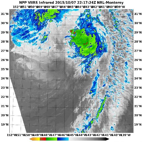 NASA-NOAA's Suomi NPP satellite showed that the remaining deep convection, clouds and showers (yellow) were pushed far to the north-northeast of Oho's center on Oct. 7 at 2217 (6:17 p.m. EDT). Credit: Credits: NASA/NRL/NOAA
Maximum sustained winds are near 70 mph (110 kph) and NOAA's Central Pacific Hurricane Center forecast calls for the storm to weaken through the morning of October 9, then strengthen late in the day and weaken again on October 10.
Becoming "extra-tropical" means that a cyclone has lost its "tropical" characteristics. The National Hurricane Center defines "extra-tropical" as a transition that implies both poleward displacement (meaning it moves toward the north or south pole) of the cyclone and the conversion of the cyclone's primary energy source from the release of latent heat of condensation to baroclinic (the temperature contrast between warm and cold air masses) processes. It is important to note that cyclones can become extra-tropical and still retain winds of hurricane or tropical storm force.
The CPHC issued their final advisory on Oho. Future information on this system can be found in high seas forecasts issued by the National Weather Service Ocean Prediction Center at: http://www.prh.noaa.gov/hnl/pages/HSFNP.php. Residents in southwestern Canada and the U.S. Pacific Northwest should monitor the progress of this extra-tropical storm as it is expected to affect the west coast over the weekend of October 10 and 11.
source: NASA/Goddard Space Flight Center