Tropical Cyclone Chapala developed in the Arabian Sea on October 28 as the fourth tropical depression in the Northern Indian Ocean basin and on October 29, strengthened into a hurricane. NASA-NOAA's Suomi NPP satellite passed over Chapala and took a visible picture of the storm that showed it had become better organized over the 24 hour period and appeared to be developing an eye feature.
On Oct. 28 at 2129 UTC (5:29 p.m. EDT) infrared imagery from the Atmospheric Infrared Sounder or AIRS instrument that flies aboard NASA's Aqua satellite looked at temperatures of Chapala's clouds. AIRS data showed strong storms within Cyclone Chapala had cold cloud tops near minus 63 degrees Fahrenheit (minus 53 degrees Celsius) circling the center of a developing eye.
On October 29 at 08:30 UTC (4:30 a.m. EDT), the Visible Infrared Imaging Radiometer Suite (VIIRS) instrument aboard NASA-NOAA's Suomi NPP satellite captured a visible image of Tropical Cyclone Chapala in the Arabian Sea. The VIIRS image showed powerful thunderstorms circling the center and feeding into the northern quadrant in a band from the northeast. The visible VIIRS image also showed the hint of a developing eye while microwave data showed an eye had developed.
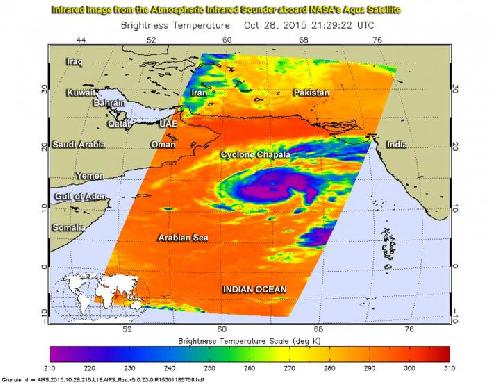 On Oct. 28 at 2129 UTC (5:29 p.m. EDT) infrared imagery NASA's Aqua satellite showed strong storms within Cyclone Chapala had cold cloud tops near -63F/-53C (purple). Credit: Credits: NASA/JPL, Ed Olsen
VIIRS collects visible and infrared imagery and global observations of land, atmosphere, cryosphere and oceans.
At 1500 UTC (11 a.m. EDT) on October 29, 2015, Tropical Cyclone Chapala's maximum sustained winds had increased to 65 knots (75 mph/120 kph). Chapala was located near 14.2 degrees north latitude and 63.1 degrees east longitude, about 446 nautical miles (513.2 miles/ 826 km) southeast of Masirah Island. Chapala is moving to the west-northwest at 8 knots (9.2 mph/14.8 kph).
The Joint Typhoon Warning Center forecast calls for Chapala intensify as it moves in a westerly direction over the next several days. Chapala is expected to peak at intensity near 115 knots (132.3 mph/213 kph) on November 1 as it passes to the north of Socotra island.
Chapala is forecast to make landfall at hurricane-strength in northeast Yemen, just south of the Yemen/Oman border on November 2.
source: NASA/Goddard Space Flight Center