False-colored night-time satellite imagery from NASA-NOAA's Suomi NPP satellite clearly shows bands of thunderstorms wrapping into the eye of Cyclone Felleng as it parallels the coast of eastern Madagascar.
The Visible Infrared Imager Radiometer Suite (VIIRS) aboard NASA-NOAA's Suomi NPP satellite captured a night-time image of Cyclone Felleng when it was located east of Madagascar (4:09 p.m. EST/Jan. 30 at 12:09 a.m. local time, Madagascar). The image was created at the University of Wisconsin-Madison and was false colored to reveal temperatures. The image shows powerful thunderstorms wrapping into the 20 nautical mile-wide (23 miles / 37 km) eye of the storm.
Felleng has intensified since Jan. 29 and as of 1500 UTC (10 a.m. EST) on Jan. 30, had maximum sustained winds near 115 knots (132.3 mph/213 kph). Felling is centered near 16.2 south and 52.6 east, about 400 nautical miles (460.3 miles/741 km) north-northwest of La Reunion Island. Felleng is moving to the southwest at 13 knots (15 mph/24 kph) and is a threat to both Madagascar and La Reunion. The storm is creating dangerous seas, with wave heights up to 38 feet (11.5 meters).
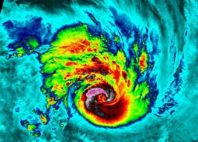
NASA-NOAA's Suomi NPP satellite captured this false-colored night-time image of Cyclone Felleng during the night on Jan. 29, at 2109 UTC. The image clearly shows bands of thunderstorms wrapping into the eye of the storm. Felleng is west of northern Madagascar.
(Photo Credit: : William Straka, UWM/NASA/NOAA)
La Reunion has already issued a Yellow Alert. For updates (in French), visit: http://www.meteo.fr/temps/domtom/La_Reunion/meteoreunion2/#
Felleng is turning towards the south and continues to intensify. The Joint Typhoon Warning Center expects Felleng to pass between La Reunion and Madagascar.
Source: NASA/Goddard Space Flight Center