The sixth tropical depression of the Atlantic Ocean hurricane season formed in the central Atlantic Ocean yesterday, and today, September 12, it strengthened into Tropical Storm Edouard. NASA-NOAA's Suomi NPP satellite flew over Edouard and provided forecasters with an infrared view of what's happening within the strengthening storm.
When Suomi NPP passed over Edouard on September 12 at 04:37 UTC (12:37 a.m. EDT), the Visible Infrared Imaging Radiometer Suite or VIIRS instrument aboard captured an infrared image of the storm. The infrared data shows temperature, an indicated that there were very high thunderstorms with very cold cloud top temperatures surrounding the center of the low level circulation.
VIIRS is a scanning radiometer that collects visible and infrared imagery and "radiometric" measurements. Basically it means that VIIRS data is used to measure cloud and aerosol properties, ocean color, sea and land surface temperature, ice motion and temperature, fires, and Earth's albedo (reflected light).
At 11 a.m. EDT (1500 UTC) the center of Tropical Storm Edouard was located near latitude 18.5 north and longitude 43.0 west. That's about 1,315 miles (2,120 km) east of the Northern Leeward Islands Edouard is moving toward the west-northwest near 16 mph (26 kph) and this motion with a gradual decrease in forward speed is expected during the next couple of days.
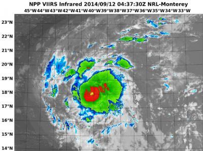
When NASA-NOAA's Suomi NPP passed over Edouard on Sept. 12 at 12:37 a.m. EDT it took this infrared image that showed very high thunderstorms with very cold cloud top temperatures surrounding the center.
(Photo Credit: Image : NRL/NASA/NOAA)
Maximum sustained winds have increased to near 45 mph (75 kph) and some slight strengthening is possible during the next two days.
Forecaster Avila of the National Hurricane Center noted that Edouard is moving toward the west-northwest at 14 knots (16 mph/26 kph) steered by the flow around the edge of a large elongated area of high pressure known as the Atlantic subtropical ridge. A gradual turn to the northwest and north is forecast in about 3 to 4 days when the ridge weakens.
The National Hurricane Center expects Edouard to become a hurricane by Monday, September 15 and stay east of Bermuda, curving back to the northeast.
Source: NASA/Goddard Space Flight Center