NASA's Aqua satellite saw Typhoon Kalmaegi's center near northern Hainan Island, China when it passed overhead on September 16 at 06:00 UTC (2 a.m. EDT). Hours later, the storm crossed the Gulf of Tonkin, the body of water that separates Hainan Island from Vietnam, and was making landfall there at 11:30 a.m. EDT.
The Moderate Resolution Imaging Spectroradiometer or MODIS instrument aboard Aqua captured a picture of the typhoon that shows the center near the northern end of Hainan Island, China, while the storm stretches over the mainland of southeastern China, east into the South China Sea and covering the Gulf of Tonkin to the west. Microwave satellite imagery showed a rounded storm with tightly curved bands of thunderstorms wrapping into the center. An eye was also seen on microwave imagery, although not seen in a visible picture.
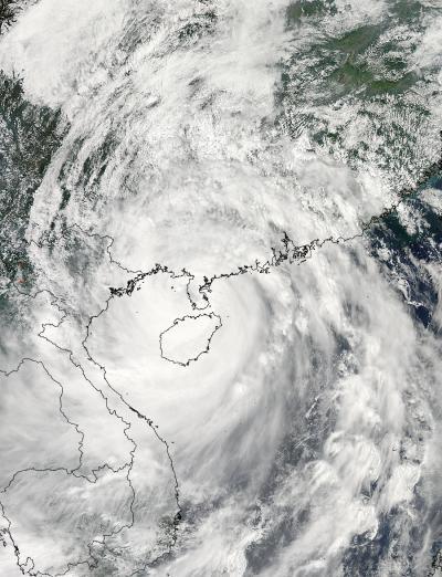
On Sept. 16 at 06:00 UTC (2 a.m. EDT) NASA's Aqua satellite saw Typhoon Kalmaegi's center near northern Hainan Island, China.
(Photo Credit: NASA Goddard MODIS Rapid Response Team)
As Kalmaegi was making landfall it was still a typhoon with maximum sustained winds near 70 knots 80.5 mph/129.6 kph). At 1500 UTC (10 a.m. EDT) it was centered near 21.3 north latitude and 107.3 east longitude, just 118 nautical miles east of Hanoi, Vietnam. It was moving to the west-northwest at 21 knots (24.7 mph/34.8 kph) and generating very rough surf and ocean swells up to 22 feet (6.7 meters).
Since the image from NASA's Aqua satellite Kalmaegi moved west through the Gulf of Tonkin and is making landfall today, September 16 in Northern Vietnam, near the border with China.
Source: NASA/Goddard Space Flight Center