Tropical Storm Odile continues to drench western Mexico and has now entered into the U.S. Southwest. On September 15, NASA's Terra satellite saw Odile's northernmost edge crossing the Mexican border into southern California. NOAA's GOES-East satellite on September 16 showed Odile's outer bands were already bringing storms to southern Arizona.
NASA Sees Odile Knocking on U.S. Border
On Sept. 15 at 2:35 p.m. EDT, the Moderate Resolution Imaging Spectroradiometer instrument aboard NASA's Terra satellite saw the northern fringes of Hurricane Odile straddling the border with southern California and Arizona. By the next day, September 16, NOAA's GOES-West satellite saw an outer band of the now weakened Tropical Storm Odile affecting Arizona.
Flood Watch in Effect for Tucson, Arizona and Surrounding Area
In the U.S., flash flood watch remains in effect from late tonight (Sept. 16) through Thursday afternoon including the greater Tucson area. The National Weather Service cautioned that the heaviest rainfall amounts will total 3 to 5 inches by late Thursday. For details visit: http://www.weather.gov.
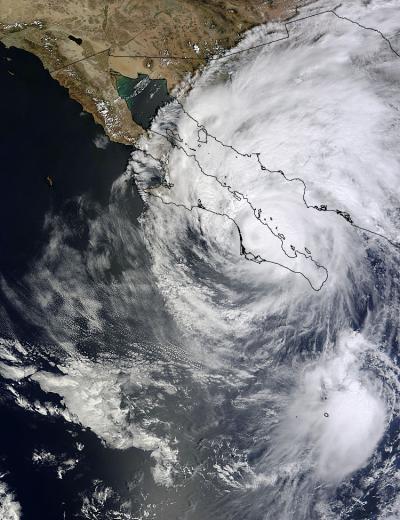
On Sept. 15 at 2:35 p.m. EDT, NASA's Terra satellite saw the northern fringes of Hurricane Odile straddling the border with southern California and Arizona.
(Photo Credit: NASA Goddard MODIS Rapid Response Team)
Warnings in Effect in Mexico
A Tropical Storm Warning is in effect for the west coast of the Baja Peninsula from Puerto San Andresito to San Jose De Las Palomas and the east coast of the peninsula from Loreto to San Felipe. In addition, a Tropical Storm Warning is up for mainland Mexico From Huatabampito to Puerto Libertad. A Tropical Storm Watch is in effect for the west coast of the Baja Peninsula north of San Jose De Las Palomas to Cabo San Quintin.
Odile's Status on September 16
At 8 a.m. EDT on September 16, the center of Tropical Storm Odile was located near latitude 28.1 north and longitude 113.0 west. Odile was moving toward the north-northwest near 10 mph (17 kph) and a turn toward the north and north-northeast is expected later in the day. Maximum sustained winds have decreased to near 60 mph (95 kph) and weakening is forecast. The estimated minimum central pressure is 994 millibars.
The National Hurricane Center noted that on the forecast track, the center of Odile will continue to move over or near the east coast of the Baja California Peninsula through today...and move over the northern Gulf of California tonight and into northern mainland Mexico on Wednesday.
A visible image on Sept. 16 at 10:11 a.m. from NOAA's GOES-West satellite showed Tropical Storm Odile moving over Baja California, Mexico and stretching into the southwestern U.S.
Odile is likely to become a tropical depression by early Wednesday, September 17.
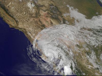
This visible image taken on Sept. 16 at 10:11 a.m. EDT from NOAA's GOES-West satellite shows Tropical Storm Odile moving over Baja California, Mexico and stretching into the southwestern US.
(Photo Credit: NASA/NOAA GOES Project)
Source: NASA/Goddard Space Flight Center