Ex-Tropical Cyclone Gillian weakened to a remnant low pressure area after making landfall in the Western Cape York Peninsula of Queensland, Australia then returned into the Gulf of Carpentaria. NASA's Aqua satellite flew over the tropical low as it struggled to re-intensify.
The MODIS or Moderate Resolution Imaging Spectroradiometer instrument that flies aboard NASA's Aqua satellite captured a visible image of Ex-Tropical Cyclone Gillian moving through Australia's Gulf of Carpentaria on March 13 at 4:25 UTC/12:45 a.m. EDT. Gillian appeared to have moved about two-thirds of the way across the Gulf from east to west toward the Northern Territory as it stayed north of Mornington Island. Satellite data indicates that thunderstorms are developing along the southern quadrant of the storm.
On March 13 at 0600 UTC/2 a.m. EDT/1:30 p.m. Darwin local time, Gillian's center was located near 14.8 south latitude and 138.0 east longitude, about 165 nautical miles/189.9 miles/305.6 km south-southeast of Gove Airport, Australia.
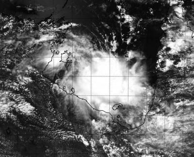
NASA's Aqua satellite captured this visible image of Ex-Tropical Cyclone Gillian moving through Australia's Gulf of Carpentaria on March 13 at 4:25 UTC/12:45 a.m. EDT.
(Photo Credit: Image : NRL/NASA)
Animated multispectral satellite imagery on March 13 showed that the storm is compact and appears to be consolidating, indicating it is intensifying. Because of that consolidation, the Joint Typhoon Warning Center has upgraded its chances to medium for re-forming.
The Australian Bureau of Meteorology or ABM noted that a building mid-level ridge (elongated area) of high pressure over Central Australia is expected to begin to steer Gillian toward the northwest later today, March 13. ABM expects Gillian to track near Nhulunbuy by 1230 UTC/10 p.m. Darwin local time on March 15 on its way to the northwest. Nhulunbuy is a township on the Gove Peninsula in the Northern Territory.
On March 13 at 9:16 a.m. EDT/1316 UTC/10:46 p.m. local time, ABM noted that a Cyclone Watch continued for a developing tropical low for coastal areas from Maningrida to Port Roper, including Alyangula. For updates from ABM, visit: http://www.bom.gov.au/cyclone/
Source: NASA/Goddard Space Flight Center