NASA's Terra satellite captured an image of Tropical Cyclone Stan on Jan 31 as it moved south through Western Australia and weakened to a remnant low pressure area.
The Australian Bureau of Meteorology said that Tropical Cyclone Stan made landfall on Jan. 30, 2016 at noon Eastern Standard Time/U.S. (1700 UTC) on the Pilbara coast of Australia just to the east of Pardoo as a category 2 cyclone.
The Moderate Resolution Imaging Spectroradiometer that flies aboard NASA's Terra satellite captured a visible image of Tropical Cyclone Stan after it landfall northwestern part of Western Australia.The image showed Stan maintained good circulation, but it was becoming elongated.
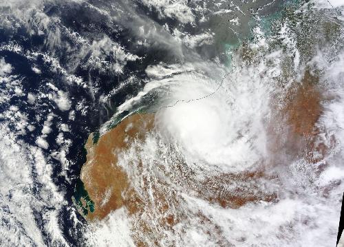 On Jan. 31, NASA's Terra satellite captured an image of Tropical Cyclone Stan as it moved south through Western Australia. Credit: Credits: NASA Goddard MODIS Rapid Response Team
Australia's Bureau of Meteorology (ABM) reported that on Jan. 31, Stan dropped 77.8 mm (3.0 inches) of rainfall at Menzies in the northern Goldfields and 40.4mm (1.5 inches) at Red Rocks Point on Eucla coast.
On January 31, the ABM said "Ex-Tropical Cyclone Stan was moving steadily to the southeast over the interior [of Western Australia]." The system continued to move south and weakened. By February 1, the remnants of Stan were absorbed by a low pressure area centered in the Southern Indian Ocean, far to the south of Western Australia's Albany Coast.
source: NASA/Goddard Space Flight Center