Tropical Cyclone Hadi is now a remnant low pressure area in the Southern Pacific Ocean. NASA's Aqua satellite passed over the storm and captured a visible image of it on March 12.
When NASA's Aqua satellite flew over Hadi's remnants, the MODIS instrument aboard captured a visible image that showed the strongest thunderstorms associated with the low appeared south of the center of circulation. The center was located near 15.1 south and 156.1 east, about 585 nautical miles/673.2 miles/ 1,083 km west of Vanuatu.
The Joint Typhoon Warning Center or JTWC noted that animated multispectral satellite imagery depicts an exposed, well-defined low-level circulation center with persistent deep convection over the southern semi-circle. The Special Sensor Microwave Imager aboard the Defense Meteorological Satellite Program satellite showed that the low-level center of circulation is elongated, and there are shallow bands of thunderstorms over the southern quadrant.
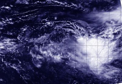
NASA's Aqua satellite flew over Hadi's remnants on March 12 and the MODIS aboard captured a visible image that showed the strongest thunderstorms associated with the low appeared south of the center of circulation.
(Photo Credit: Image : NRL/NASA)
The JTWC noted on March 12, "Based on the lack of convective structure, marginal environment and weak model development, the potential for the development of a significant tropical cyclone within the next 24 hours is downgraded to low."
Source: NASA/Goddard Space Flight Center