Wind shear has caused the demise of former Tropical Cyclone Nilofar in the northern Arabian Sea. NASA's Aqua satellite passed over Nilofar on Oct. 31 and captured an image that shows strong wind shear has pushed the bulk of clouds and showers away from Nilofar's center, basically sending the storm to its grave.
The Moderate Resolution Imaging Spectroradiometer aboard NASA's Aqua satellite captured an image of the remnants of Tropical Cyclone Nilofar on Oct. 31 at 08:45 UTC (4:45 a.m. EDT). The image showed that the former tropical cyclone's clouds and showers were pushed northeast of the center from strong southwesterly wind shear. The clouds blanketed the Pakistan/India border.
The Joint Typhoon Warning Center issued the final warning on Nilofar the previous day, Oct. 30 at 2100 UTC (5 p.m. EDT). At that time, Nilofar's maximum sustained winds had dropped to 35 knots and weakening fast. It was centered near 20.5 north latitude and 65.0 east longitude, about 281 miles south-southwest of Karachi, Pakistan. Nilofar was moving to the northeast and dissipating.
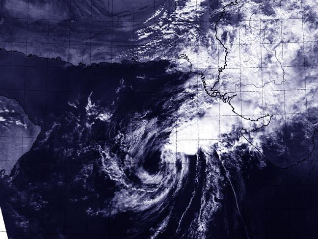
NASA's Aqua satellite captured this image on Oct. 31 at 08:45 UTC (4:45 a.m. EDT) as the Remnants of Cyclone Nilofar were ripped apart by wind shear in the Arabian Sea.
(Photo Credit: Image : NASA Goddard MODIS Rapid Response Team)
On Oct. 31, India's Regional Specialized Meteorological Service or RSMC forecast said Cyclone Nilofar is expected to bring moderate rainfall to many places over Kutch and Saurashtra with squally winds there and along and off the Gujarat coast during next 24 hours. Seas along the Gujurat coast are expected to be rough for the next day or two. For the full bulletin, visit: http://www.rsmcnewdelhi.imd.gov.in/images/cyclone_pdfs/indian_1414757342.... For updated forecasts, visit: http://www.rsmcnewdelhi.imd.gov.in.
Nilofar is expected to be in its grave by the end of Halloween day, Oct. 31.
Source: NASA/Goddard Space Flight Center