Tropical Depression 10 appeared more organized on NOAA's GOES-13 satellite imagery early on Aug. 23 (Eastern Daylight Time) and it was renamed Tropical Storm Joyce by the National Hurricane Center by 11 a.m. EDT
When NOAA's GOES-13 satellite captured an image of Tropical Depression 10 (TD10) on Aug. 23 at 7:45 a.m. EDT it appeared to have a well-rounded circulation. Infrared imagery indicated cold cloud top temperatures. Cold cloud top temperatures as cold as -63 Fahrenheit (-52 Celsius) show strength in the uplift of air that helps create strong thunderstorms that make up the tropical cyclone. The GOES-13 image was created using the NOAA satellite data at NASA's GOES Project, located at NASA's Goddard Space Flight Center in Greenbelt, Md.
On Aug. 23 at 11 a.m. EDT, Tropical Storm Joyce had maximum sustained winds near 40 mph (65 kmh). Joyce was located far from land, about 1,305 miles (2,105 km) east of the Leeward Islands near 15.2 North latitude and 42.2 West longitude. It was moving to the west-northwest near 17 mph (28 kmh).
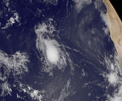
This visible image of Tropical Storm Joyce was captured by NOAA's GOES-13 satellite on Aug. 23 at 7:45 a.m. EDT.
(Photo Credit: NASA GOES Project)
Satellite data indicates that Joyce is dealing with a dry Saharan air layer, something that usually saps a tropical cyclone's warm, moist air. That dry air is wrapping around the southwestern part of Joyce's circulation.
The Saharan Air Layer is one thing that NASA is going to investigate in its upcoming Hurricane Severe Storm Sentinels (HS3) mission in September, using unmanned aircraft. For more information, go to: http://www.nasa.gov/HS3.
The National Hurricane Center noted that Joyce is following the southern edge of a subtropical ridge (elongated area) of high pressure over the Central Atlantic Ocean. Think of a marble rolling around the edge of a round clock. Once Joyce (the marble in this example) reaches the western edge, it will begin to turn to the northwest and then to the north.
Source: NASA/Goddard Space Flight Center