Tropical Cyclone Jack had weakened to a tropical depression when NASA and JAXA's Tropical Rainfall Measuring Mission (TRMM) satellite passed above on April 22, 2014 at 1120 UTC/7:20 a.m. EDT.
At that time, TRMM found that Jack was devoid of almost all rainfall near the tropical cyclone's center. Outside the center was a different story, however. That's where TRMM's precipitation radar instrument found rain falling at a rate of over 130mm/hr (about 5.1 inches) in a band of thunderstorms that stretched from east of Jack's center to the south. Some of the thunderstorms even stretched as high as 15 km (9.3 miles).
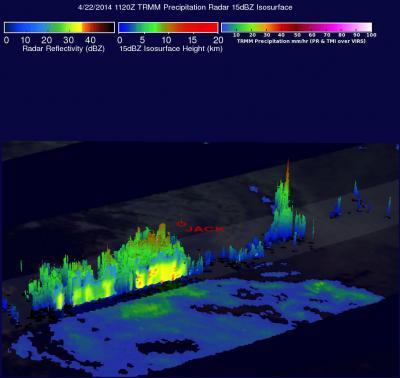
NASA's TRMM satellite passed overhead on April 22 and saw that the bulk of Tropical Cyclone Jack's rainfall was being pushed south of the center from the wind shear.
(Photo Credit: Image : NASA/SSAI/JAXA)
Wind shear continued to pummel the tropical cyclone and by April 23, Jack had fizzled in the Southern Indian Ocean.
Source: NASA/Goddard Space Flight Center