NASA's Aqua satellite passed over Tropical Cyclone Hudhud on Oct. 10 as it reached hurricane-force.
The Atmospheric Infrared Sounder or AIRS instrument that flies aboard NASA's Aqua satellite read temperatures of thunderstorm cloudtops that make up Tropical Cyclone Hudhud when it passed overhead on Oct. 9 at 19:53 UTC (3:53 p.m. EDT). The data showed the coldest cloud top temperatures were in thunderstorms circling a developing eye. Cloud top temperatures were as cold as -63F/-53C, which have the potential for dropping heavy rainfall.
Hudhud's maximum sustained winds were nearer 75 knots (86.3 mph/138.9 kph) on Oct. 10 at 1500 UTC (11 a.m. EDT). It was centered near 15.5 north and 86.7 east, about 250 nautical miles (155.3 miles) southeast Visakhapatnam, India. Hudhud has tracked northwestward at 6 knots (6.9 mph/11.1 kph).
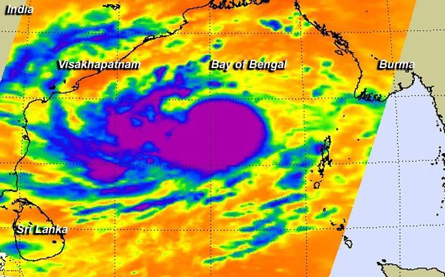
NASA's Aqua satellite took this infrared image of Tropical Cyclone Hudhud on Oct. 9 at 3:53 p.m. EDT. Cloud top temperatures (purple) were as cold as -63F/-53C, which have the potential for dropping heavy rainfall.
(Photo Credit: NASA JPL, Ed Olsen)
Forecasters at the Joint Typhoon Warning Center indicated on Oct. 10 that animated enhanced infrared satellite imagery showed that bands of thunderstorms have become more tightly wrapped into the low-level center. In addition, microwave satellite data revealed an eye in the storm.
The Joint Typhoon Warning Center (JTWC) expects the cyclone to remain on a generally west-northwestward trajectory over the next couple of days. Forecasters at JWTC noted that because conditions are favorable in the area, Hudhud is expected to intensify and peak around 100 knots before landfall near Visakhapatnam late on Oct. 12 (EDT). For updated forecasts, visit India's Regional Specialized Meteorological Centre (RSMC): http://www.rsmcnewdelhi.imd.gov.in.
After landfall, Hudhud is expected to erode quickly because of interaction with land, and dissipate.
Source: NASA/Goddard Space Flight Center