After tropical cyclones reach their peak intensity and continue to age, it's not uncommon for their wind field (i.e., circulation) to expand. That is the case with Edouard, this can happen as the result of an "eyewall replacement cycle" where a newer outer eyewall forms around the original eyewall creating a double eye-wall structure (i.e., the two concentric rainbands) and another ring of stronger winds around the center but further out.
At that time, Edouard's minimum central pressure was 959 millibars and is nearly as low as it was when Edouard was a category 3 hurricane on the Saffir-Simpson scale, but the pressure gradient is now spread over a larger area, which reduces the storm's peak wind intensity but increase the extent of stronger winds over a larger area.
Getting a 3-D Look at the Storm
At NASA's Goddard Space Flight Center in Greenbelt, Maryland the TRMM team created a 3-D image of Edouard using TRMM Precipitation Radar data. The 3-D image showed that there was little in the way of the tall convective (rising air that forms) thunderstorm towers that can energize the storm's circulation. That's because Edouard was beginning to move over cooler waters. TRMM is a joint mission between NASA and the Japanese space agency JAXA.
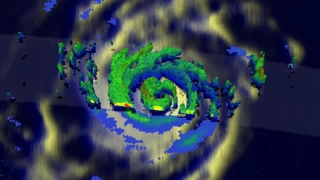
On Sept. 17 at 03:39 UTC, the TRMM satellite saw a newer outer eyewall forming around Edouard's original eyewall creating a double eye-wall structure. Red indicates heavy rainfall.
(Photo Credit: NASA/SSAI, Hal Pierce)
NASA's Aqua Satellite Passed Over Edouard
On Sept. 17 at 12:40 p.m. EDT the Moderate Resolution Imaging Spectroradiometer or MODIS instrument aboard NASA's Aqua satellite took a visible picture of Hurricane Edouard in the Atlantic Ocean. Edouard's eye had become obscured by high clouds. The image revealed bands of thunderstorms spinning into the center from the northern and southern quadrants. The image was created by the NASA Goddard MODIS Rapid Response Team at NASA Goddard.
NASA's HS3 Mission Flying Over Edouard Sept. 18
The remotely piloted Global Hawk aircraft is part of NASA's airborne Hurricane and Severe Storm Sentinel, or HS3 mission that has been investigating tropical cyclones in the Atlantic this summer. The Global Hawk took off from NASA's Wallops Flight Facility, Wallops Island, Virginia, at 7:15 EDT to start Science Flight #8 to Hurricane Edouard
On Sept. 18 at 8 a.m. EDT, the National Hurricane Center noted the Edouard was still a hurricane despite moving over waters near 24 Celsius (75.2 Fahrenheit). Sea surface temperatures of at least 26.6C (80F) are needed for a hurricane to maintain strength, so it's only a matter of time until Edouard weakens below hurricane status.
Where is Edouard?
At 5 a.m. EDT on Sept. 18, the center of Hurricane Edouard was located near latitude 39.6 north and longitude 45.3 west. Edouard was moving toward the east-northeast near 28 mph (44 kph) and is expected to slow down as it moves eastward. Maximum sustained winds remain near 85 mph (140 kph) and weakening is forecast during the next 48 hours.
Edouard continues to move to the northeast away from the U.S. and is expected to begin to weaken and become post tropical before winding up somewhere west of the Azores in the next few days.
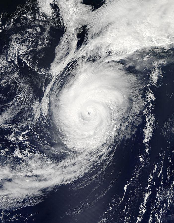
This image shows Hurricane Edouard in the Atlantic Ocean on Sept. 17 at 12:40 p.m. EDT as seen by the MODIS instrument aboard NASA's Aqua satellite.
(Photo Credit: NASA Goddard MODIS Rapid Response Team)
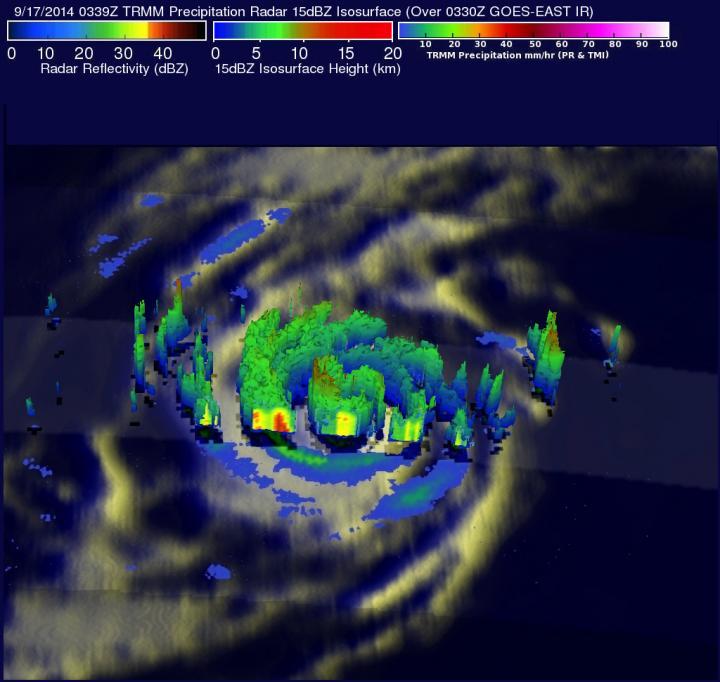
On Sept. 17 at 03:39 UTC, the TRMM satellite saw a newer outer eyewall forming around Edouard's original eyewall creating a double eye-wall structure. Red indicates heavy rainfall.
(Photo Credit: NASA/SSAI, Hal Pierce)
Source: NASA/Goddard Space Flight Center