Tropical Depression Haima, formerly known as 06W continues moving toward Hong Kong and NASA infrared satellite imagery shows strong rain-making thunderstorms in the southern quadrant of the storm. Rainfall is something that a rain-weary China doesn't need, so preparations are being made now.
Heavy rainfall is expected as Haima approaches in southern Taiwan, and also in southern areas of China's Fujian and Guangdong provinces, and Hainan Island. That heavy rainfall was spotted on an infrared image captured by NASA's Atmospheric Infrared Sounder (AIRS) instrument on June 22 at 05:41 UTC (1:41 a.m. EDT). AIRS flies on NASA's Aqua satellite. This image showed that most of the strongest thunderstorms in Tropical Depression Haima were south of the center of circulation and none are on the northern side. The cloud top temperatures in those thunderstorms were colder than the -63 degree Fahrenheit/-52 Celsius threshold on AIRS data, indicating they are very high, cold cloud tops and likely harbor heavy rainfall (about 2 inches/50 mm per hour).
AIRS data also shows that Haima is not well organized. One interesting feature that appeared on multispectral satellite imagery was that Haima has "multiple surface circulation center orbiting within the broad overall circulation," according to the Joint Typhoon Warning Center (JTWC). Almost like smaller low pressure areas in the larger low pressure area.
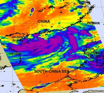
Tropical Depression Haima's (center) cold thunderstorm cloud tops were captured on this infrared image from NASA's AIRS instrument on June 22 at 05:41 UTC (1:41 a.m. EDT). AIRS flies on NASA's Aqua satellite. This image shows most of the strongest thunderstorms (purple) in Haima are south of the center of circulation and none on the northern side. The eastern edge of Tropical Storm Meari is located to the far right near Luzon.
(Photo Credit: NASA/JPL, Ed Olsen)
In anticipation of Haima, the Deccan Herald on-line reported that passenger ship operations in the south Qiongzhou Strait have already been suspended. Airline flights were also suspended yesterday and again today from the Meilan International Airport in Haikou.
On June 22 at 1500 UTC (11 a.m. EDT), Haima's maximum sustained winds were down to 25 knots (29 mph/46 kmh). It was still 145 nautical miles southwest of Hong Kong, near 20.9 North and 111.8 East. Haima is moving to the northwest at 7 knots (8 mph/13 kmh).
Strong wind shear between 20 and 30 knots (23 and 36 mph/37 and 55 kmh) continues to batter Haima, so the JTWC doesn't expect any strengthening before it makes landfall in China.
Source: NASA/Goddard Space Flight Center