CPHC said the onset of tropical storm conditions is expected on the Big Island of Hawaii this afternoon (August 7), with hurricane conditions expected tonight. Tropical storm conditions are expected over Maui County Tonight (August 7), over Oahu on Friday (August 8) and over Kauai county on Friday afternoon.
On August 6 at 22:30 UTC (6:30 p.m. EDT) NASA's Aqua satellite passed over Hurricanes Iselle and Julio approaching Hawaii. The Moderate Resolution Imaging Spectroradiometer (MODIS) instrument captured a visible image of both storms as the march in a line across the Central and Eastern Pacific.
At 5 a.m. HST (11 a.m. EDT)/1500 UTC) the center of Hurricane Iselle was located near latitude 18.5 north and longitude 150.6 west, about 305 miles (490 km) east-southeast of Hilo, Hawaii. Iselle was moving toward the west-northwest near 17 mph (28 kph) and this motion is expected to continue through Friday, with some slowing in forward speed on Friday night. On the forecast track, the center of Iselle is expected to pass over the Big Island tonight, and pass just south of the smaller islands Friday.
Maximum sustained winds are near 80 mph (130 kph). Some weakening is forecast during the next 48 hours, but Iselle is expected to be near hurricane strength as it makes landfall on the Big Island tonight, August 7. The estimated minimum central pressure is 986 millibars. For updates from the CPHC, visit: http://www.prh.noaa.gov/.
Hurricane Iselle is predicted to cause tropical storm conditions with potential flash floods in the Hawaiian Islands on Thursday and Friday. Tropical storm Julio is expected to also affect the island chain over the weekend.
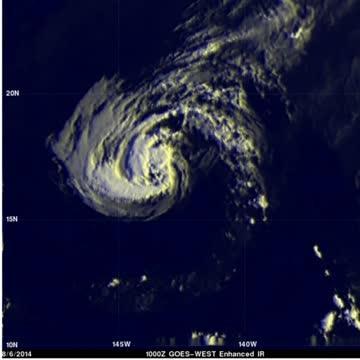
TRMM satellite rainfall data overlaid on an enhanced infrared image from NOAA's GOES-West satellite shows heavy rainfall occurring around the Iselle's eye. The most intense rain was falling at a rate of over 43.5 mm (about 1.7 inches) in a band southwest of the eye.
(Photo Credit: : SSAI/NASA, Hal Pierce)
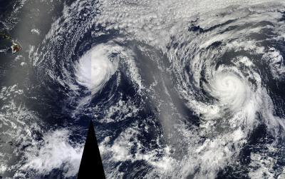
On Aug. 6 at 22:30 UTC (6:30 p.m. EDT) NASA's Aqua satellite passed over Hurricanes Iselle and Julio approaching Hawaii. This image was created using three satellite passes.
(Photo Credit: Image : NASA Goddard MODIS Rapid Response Team)
Source: NASA/Goddard Space Flight Center