Tropical Depression 30W formed in the northwestern Pacific Ocean basin and crossed into the Northern Indian Ocean from Nov. 8 to Nov. 10. By Nov. 12, NASA satellite imagery saw the ex-tropical depression coming back together.
The Moderate Resolution Imaging Spectroradiometer or MODIS instrument aboard NASA's Terra satellite captured an image of ex-tropical depression 30W on Nov. 12 at 04:55 UTC when it was about 440 nautical miles/506 miles/ 814.9 km east-southeast of Chennai India. 30W is a large low-level center with strong bands of thunderstorms wrapped around the northern quadrant of the storm. However, dry air is now wrapping around the western quadrants. Forecasters at the Joint Typhoon Warning Center noted that animated infrared satellite imagery showed that strong convection and weak convective banding of thunderstorms are wrapping into a defined low-level circulation center.
On Nov. 12, ex-depression 30W was centered near 11.4 north and 85.9 east, approximately 350 nautical miles/402.8 miles/648.2 km east-southeast of Chennai, India.
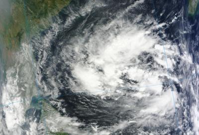
The MODIS instrument aboard NASA's Terra satellite captured this image of ex-tropical depression 30W on Nov. 12 at 04:55 UTC when it was about 440 miles east-southeast of Chennai India.
(Photo Credit: Image : NASA Goddard MODIS Rapid Response Team)
30W is expected to move slowly to the west. Maximum sustained surface winds are estimated at 20 to 25 knots/23 to 28.7 mph/37 to 46.3 kph. The Joint Typhoon Warning Center gives 30W a medium chance for re-generation in the next couple of days.
Source: NASA/Goddard Space Flight Center