NASA's Aqua satellite passed over Cyclone Helen as it was making landfall in eastern India on November 22.
The AIRS instrument, or Atmospheric Infrared Sounder that flies aboard NASA's Aqua satellite, captured infrared data on Helen on November 21 at 20:05 UTC/3:05 p.m. EST. At that time, Helen had just begun to make landfall and moderate rainfall from the storm's northwestern edge was over the coast. Helen's western cloud cover extended from Kolkata south to Chennai at the time.
By 0900 UTC/4 a.m. EST on November 22, animated multispectral satellite imagery showed a fully-exposed low level circulation as Helen was making landfall near Machillipatnam.
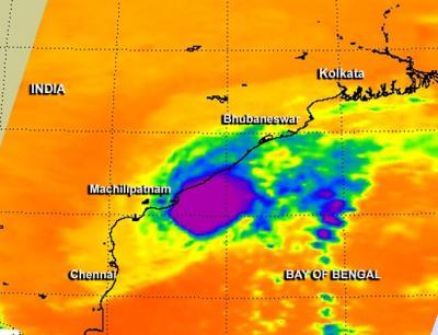
The AIRS instrument aboard NASA's Aqua satellite captured infrared data on Helen as it flew overhead on Nov. 21 at 20:05 UTC/3:05 p.m. EST. Helen's western cloud cover (yellow) extended from Kolkata south to Chennai at the time.
(Photo Credit: Image : NASA JPL, Ed Olsen)
Warnings were still in effect for Andhra Pradesh and rainfall totals of up to 10 inches/~250 mm are possible. The warning also cautioned fishermen to stay in port.
The Joint Typhoon Warning Center issued their final bulletin on Cyclone Helen on November 22 at 0900 UTC/4 a.m. EST. Maximum sustained winds were near 35 knots/40 mph/62 kph at the time of landfall. At that time, Helen was located near 16.2 north latitude and 81.0 east longitude, about 193 nautical miles/222.1 miles/ 357.4 km north-northeast of Chennai, India. Helen was moving to the west at 7 knots/8.0 mph/12.9 kph near Tenali while heading further inland.
Helen is expected to continue moving westward and dissipate over land in the next day or two.
Source: NASA/Goddard Space Flight Center