Cyclone Evan is no more than a remnant low pressure area in the South Pacific Ocean now. NOAA's GOES-15 satellite captured an image of the remnants from its fixed orbit in space on Dec. 20 that showed strong wind shear had basically blown the storm apart.
The last official bulletin by the Joint Typhoon Warning Center was issued on Dec. 19 at 2100 UTC (4 p.m. EST/U.S. or 12:56 a.m. Fiji local time on Dec. 20). At that time, Evan's maximum sustained winds were still near 35 knots (40 mph/64.8 kph) and it had transitioned into an extra-tropical storm. It was located 400 nautical miles south of Nadi, Fiji, near 24.3 south latitude and 178.5 east longitude. Evan was moving to the south-southeast at 4 knots (4.6 mph/7.4 kph). Evan has since become a remnant low pressure system.
NOAA's GOES-15 satellite captured an infrared image of Evan's remnants on Dec. 20 at 1500 UTC (10 a.m. EST) showed the remnants of former Tropical Cyclone Evan blown apart by very strong wind shear, northeast of New Zealand. The low pressure center appears northwest of the plume of clouds associated Evan's remnants. The image was created by NASA's GOES Project, located at NASA's Goddard Space Flight Center in Greenbelt, Md.
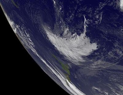
This infrared image from NOAA's GOES-15 satellite on Dec. 20 at 1500 UTC (10 a.m. EST) shows the remnants of former Tropical Cyclone Evan blown apart by very strong wind shear, northeast of New Zealand (lower left). The low pressure center is northwest of all of Evan's associated remnant clouds.
(Photo Credit: NASA / NOAA GOES Project)
Northwesterly wind shear continued to be very strong, blowing between 40 and 50 knots (46 and 57.5 mph/74 and 92.6 kph) and cooler ocean waters were weakening Evan quickly.
Evan has now gone into the history books as one of the strongest cyclones to hit Fiji and American Samoa in recent memory.
Source: NASA/Goddard Space Flight Center