Visible and infrared satellite data show strong thunderstorms surrounding the low-level center of the tropical storm turned Typhoon Soulik. NASA's Aqua satellite passed over Typhoon Soulik in the Northwestern Pacific Ocean on July 9 and two instruments showed the power in the typhoon's center.
The Moderate Resolution Imaging Spectroradiometer or MODIS instrument that flies aboard NASA's Aqua satellite captured a visible image of Soulik on July 9 at 1:25 UTC (July 8 at 9:25 p.m. EDT). The image shows a tight concentration of thunderstorms around the typhoon's center and feeder bands of thunderstorms wrapping into the center from the northeast and southwest.
An infrared image captured on July 9 at 4:29 UTC (12:29 a.m. EDT) captured the cloud top temperatures of the eastern two-thirds of the typhoon. The infrared data, captured by the Atmospheric Infrared Sounder or AIRS instrument showed that same tight concentration of storms around the center with cloud top temperatures colder than -63F/-52C. That means the thunderstorm cloud tops are high into the troposphere and are likely dropping heavy rainfall. Infrared data shows that Soulik's eye is about 30 nautical miles (34.5 miles/55.5 km) in diameter.
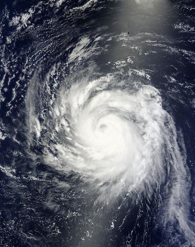
This visible image from July 9 at 1:25 UTC was taken by the MODIS instrument that flies aboard NASA's Aqua satellite shows strong thunderstorms around Tropical Storm Soulik's center.
(Photo Credit: NASA Goddard MODIS Rapid Response Team)
Soulik is also a large typhoon. The AIRS data showed that the storm spans from about 15 degrees north latitude to 23 degrees north latitude. Tropical-storm-force winds extend out 140 miles from the center (or 280 miles in diameter). The typhoon-force winds extend out nautical 40 miles (46 miles/74 km) from the center, or about 80 nautical miles (92 miles/148 km) in diameter.
According to the Joint Typhoon Warning Center, on July 9 at 1500 UTC (11 a.m. EDT), Typhoon Soulik had maximum sustained winds near 95 knots (109 mph/176 kph) and is still strengthening.
Soulik's center was located near 20.3 north latitude and 138.1 east longitude, about 678 nautical miles (780 miles/1,256 km) east-southeast of Kadena Air Base, Japan. Soulik is moving to the west-southwest at 12 knots (13.8 mph/22.2 kph) and generating very rough seas with wave heights to 32 feet (9.7 meters).
Soulik is intensifying as it moves west across the open Pacific and is expected to make a landfall in southeastern China sometime over the weekend of July 13 and 14.
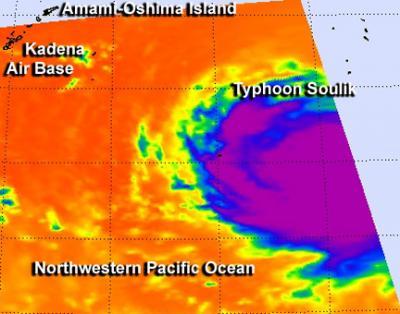
NASA's AIRS instrument showed the concentration of strong thunderstorms around Soulik's center with cloud top temperatures colder than -63F/-52C (purple) and an eye about 30 nautical miles in diameter.
(Photo Credit: NASA/JPL, Ed Olsen)
Source: NASA/Goddard Space Flight Center